Scientific Report 977
This report is also available as a PDF document .
Abstract
This loan formed an additional aspect to a European Facility for Airborne Research (EUFAR) funded project entitled “A Study of the Hazard and Geomorphic Change Caused by Debris Flows in Iceland”. This EUFAR project included the acquisition of LiDAR (airborne laser altimeter) and air photography by the NERC ARSF (EUFAR12_02). Four differential GPS were used by two different field teams to provide support for a NERC ARSF deployment on 27 August 2012 and over an additional week to make GPS measurements for qualitycheck and georeferencing purposes. These data collection activities were successful and although weather conditions prevented the key site from being surveyed, aerial data were collected elsewhere that enabled the support of a number of different projects being pursued by the project team-members. The LiDAR and air photo datasets are being used actively by the project teams to support three themes of research: 1) paraglacial slope adjustment in Iceland led by J. Coquin supervised by team member A. Decaulne, 2) a PhD project by A.M. Barratt under the supervision of team member M.R. Balme concerning periglacial landforms and 3) as an analogue for investigations into martian surface processes lead by S.J. Conway. Because airborne LiDAR data could not be collected near Ísafjörður we performed GPS surveys over two new debris flows to contribute to the initial project aims and to the monitoring dataset are building on the debris flows in this area. These data will be used in a new PhD project concerning mass flows in Iceland, to start in October 2014.
Background
One of the main risks to population in Iceland, particularly in the fjords, is the action of debris flows. These are mixtures of boulders, sediment and water that surge downslope after prolonged/intense rainfall or sudden snowmelt (Decaulne et al., Geogr. Ann. Ser. A-Phys. Geogr.2005). Metre-size boulders can be carried in debris flows causing damage to property and, in some cases, loss of life. To better understand the risk posed by these flows, both the physics of their motion and the role of the geological setting in initiating slope instability need to be understood. We initially proposed to collect high resolution topographic data in Súgandafjörður and Skutulsfjörður, which were previously surveyed by NERC ARSF in 2007, and from the slopes of western Skagafjörður (Tindastóll).
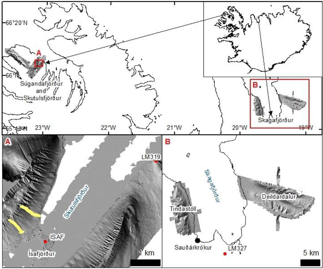
Unfortunately, due to poor weather conditions, the sites in Súgandafjörður and Skutulsfjörður were not surveyed and an additional site at Deildardalur was surveyed instead (Fig. 1). These sites were key to pursuing the theme of debris flow research as outlined in the original EUFAR proposal and this line of research was put on hold until collection of these key data occurred in summer 2013. This project now forms part of a PhD project starting in October 2014 under the supervision of some of the EUFAR team members. Some GPS survey data were obtained as part of this loan to partially compensate for the lack of LiDAR survey and these will be used as part of this PhD project. Although the initial aims of the project could not be completed these data have been used for three other projects with details in the following sections.
Paraglacial slope adjustment
The Skagafjörður region is comprised of layered basaltic bedrock forming plateaus that are dissected by glacial valleys. This region has been ice-free since the early Holocene and post-glacial processes are thought to have contributed to the slope instability of this area, with >130 landslides mapped in this area (Pétursson, Skagfirsk náttúra 2008). Paragalcial landforms such as landslides and rock slope failures have been studied in this region, but little attention has been paid to deep-seated gravitational slope deformation - so called “sackung”. Such features are found at the crests of the Óslandshliðarfjöll Mountain within the Deildardalur site and the LiDAR data and aerial photo mosaic have enabled detailed study of these features by PhD student J. Coquin under the supervision of team member A. Decaulne.

Periglacial processes
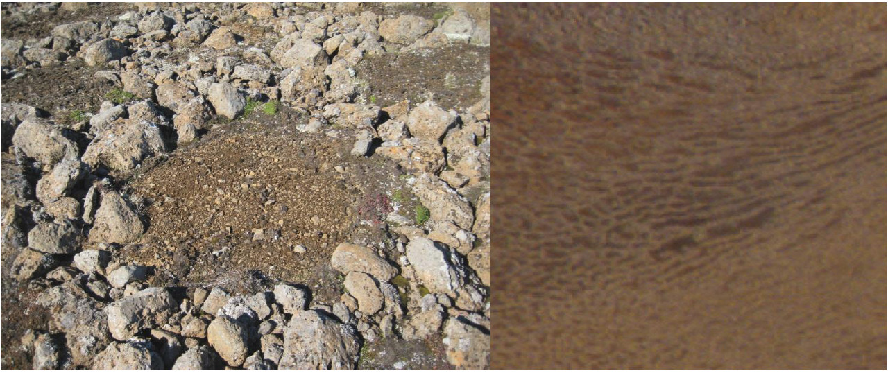
The repeated freezing and thawing of the permafrost active layer in periglacial environments can result in the sorting of mixed soils into domains of fine particles surrounded by circles or lines of larger stones. Active sorted stone circles are found on top of Tindastóll mountain, with relic features in other parts of the Skagafjörður area (Feuillet et al., Geomorphology 2012). The sorting process itself is poorly understood and the PhD project of A. M. Barrett, supervised by team member M. R. Balme, aims to 1) determine the extent to which sorted circle morphology is controlled by topographic factors as predicted by the models of Kessler and Werner (Science, 2003) and 2) to determine if the sorted forms that we have observed on Mars are also controlled in the same way.
Martian analogue studies
Martian gullies are kilometre-scale landforms that strongly resemble gullies formed by water-driven processes on Earth; however we know that they formed within the last few million years when the climate has been too dry and cold to support the production of liquid water at the surface. Martian gullies can be visually similar to gullies carved by debris flows in Iceland. We have used hydrological analysis techniques on high resolution elevation models (from LiDAR and stereo photogrammetry) to successfully demonstrate that gullies on Mars resemble Icelandic debris flow gullies in terms of their 3D attributes as well as visually (Conway et al., Geol.Soc. Sp. Ed. 2011). Hence, we showed that water was recently active on Mars’ surface and therefore Mars must have undergone dramatic changes in climate during this time. In Conway et al., (Geol.Soc. Sp. Ed. 2011) we used the LiDAR data of Ísafjörður area from 2007. The data from 2012 will build on this existing analogue dataset and allow further comparison of martian gullies with debris flows with different configurations and settings compared to those near Ísafjörður.
Survey Procedure
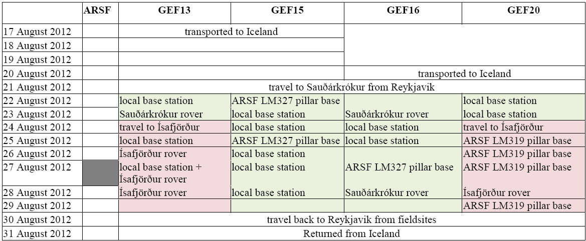
To directly support the ARSF surveys we set up the differential GPS on survey pillars with known positions at Sauðárkrókur and Ísafjörður (Fig. 1; LM327 and 319). The tribrachs were directly screwed onto the pillars and the distance from the antennae’s reference plane to the reference plates on the pillars were measured. The GPS were deployed 1.5 hours prior to the planned survey at 1s recording rate and taken down once confirmation of the survey being completed was received. A backup station was set up nearby on a tripod, in case the GPS on the pillar failed.
In order to collect some ground control data to assist in quality control and processing of the aerial LiDAR data we collected additional GPS data using a rover-base station pair. We collected data along roads and around other objects visible from the air (building footprints, abandoned tractor tyres, etc). Firstly we set up a local base station, which we ran simultaneously with another GPS setup on the known-pillar position, to tie it in to the same frame of reference as the aerial survey. Then, while maintaining this local base station, we operated one or two rovers, collecting 5-10 epochs of data at each survey point.
Lastly we collected data over the deposits of two debris flow that occurred since the 2007 LiDAR survey in Ísafjörður to partly compensate for the lack of repeat LiDAR collection. A similar approach was used to that outlined above for the quality control data. After successful testing we surveyed on one day using the permanently recording GPS in Ísafjörður (ISAF) as the base station, enabling us to use two rovers.
Data quality
Pillar LM327 was occupied for 9h 56m between the hours of 08:37 and 18:33 on 27th August and a position quality of better than 1cm was reported in all orientations. The western Skagafjörður site was flown between 10:05 and 11:04 and the Deildardalur site between 13:35 and 15:52. Static GPS data for Ísafjörður was not used as this site was not flown. The backup station’s data were not required.
In total 2344 datapoints were collected for quality control and GPS survey purposes. These points had an average vertical error of < 9cm for surveys on rough terrain and < 3cm for control point surveys. The horizontal error was always < 3cm. A summary of the errors is given in Table 1. The maximum value of the errors are within the expected range for errors introduced by terrain roughness and user point-positioning, hence are within acceptable bounds for this kind of data collection.

Processing and modelling
The GPS data collected to support the ARSF survey were sent to the NERC ARSF Data Analysis Mode and they used them together with data from the aircraft’s GPS and Inertial Measurement Unit (IMU) to produce a georeferenced pointcloud of LiDAR data and camera external orientation parameters for the aerial photographs. The LiDAR points were gridded at 1 m/pix using LasTools and the aerial photographs mosaiced using Agisoft PhotoScan with control points picked from the LiDAR data.
The quality control and survey GPS data were post-processed using the Leica GeoOffice Software and exported to an ArcGIS shapefile for further analysis. The quality control data were then passed directly to the NERC ARSF DAN for checking their LiDAR data processing.

Interpretation & Preliminary findings to date
Change caused by debris flows
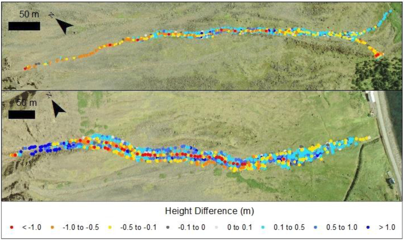
By comparing the elevation values recorded in the GPS survey of two debris flows above Ísafjörður with the digital elevation model produced from the 2007 LiDAR data we were able to perform an initial analysis on the topographic change engendered by these flows (Fig. 2). Unexpectedly 2-3 m of deposition was recorded within the alcove of the large debris flow (as corroborated by visual observations), which we infer could engender future debris flows. Our intention is to bring together these observations with observations derived from the new ARSF LiDAR survey flown in 2013 to publish on the potential for future debris flow events in this region derived from mass movement into the alcoves.

Paraglacial slope adjustment
J. Coquin and co-authors (Coquin et al., Earth Science Reviews 2014) have identified and mapped (using the LiDAR, air photo and field measurements) three distinctive set of graben trending along a 12 km ridge section in the mountains in the Deildardalur site. From these data they suggest that these graben are caused by a sackung-style of gravitational spreading. They conclude that this deformation started before the ice was completely removed (during the early stage of the Late Weichselian deglaciation), rather than after its removal as is commonly believed. They surmised that the role of sackung in long term mountain denudation and land scape evolution under a paraglacial landscape system is more important than previously thought.
Periglacial processes
From field observations and by using the aerial photography from the NERC ASF survey A.M. Barrett recorded a range of types and scales of sorted patterned ground in the western Skagafjörður region (Fig. 3), which are similar to those he has observed in his martian datasets. Analysis is ongoing and he plans to integrate the topographic data with the image data in order to assess the topographic control of the forms in Skagafjörður and on Mars.

Martian analogue
We have used the western Skagafjörður LiDAR dataset and used it as a debris flow end-member in a study where we compare the 3D terrain attributes of martian gullies to dry lunar gullies and to wet terrestrial fluvial and debris flow gullies in order to ascertain the moistness of the martian gullies. We conclude that martian gullies are unlike dry lunar gullies and are intermediate between fluvial and debris flow gullies on Earth. This confirms the findings of our previous work where we concluded that water has been recently active on Mars’ surface and therefore Mars must have undergone dramatic climate changes in the last few million years. This work is in preparation for publication and is funded by Leverhulme Trust grant number RPG-397. We plan to use these data in future to compare the 3D attributes of features that are interpreted to be solifluction lobes and rock glaciers on Mars to those found within the LiDAR surveys in Skagafjörður.
Conclusions and recommendations
The four NERC GEF GPS were used to fulfil the primary objective of supporting the EUFAR funded NERC ARSF flights in Iceland in 2012. They were also used to collect ground control data to assist in the quality control of the data by NERC ARSF DAN. As a result, correctly georeferenced aerial photo mosaics and digital elevation models were produced of the two survey sites, which although could not be used as intended for the initially proposed project (because the survey of the key site was abandoned due to weather constraints), have contributed to three other lines of research. The GPS were also used to collect additional data over two debris flows in Ísafjörður, which were not covered by the aerial survey as planned. These data will contribute to the ongoing monitoring of debris flow activity in this area and will support a PhD project starting in October 2014.
Publications
Journal Publications
Julien Coquin, Denis Mercier, Olivier Bourgeois, Etienne Cossart & Armelle Decaulne (submitted).Mountain gravitational spreading coeval with Late Weichselian deglaciation: impact on glacial landscapes in Tröllaskagi, North Iceland. Earth Science Reviews.
Conference presentations
Julien Coquin, Denis Mercier, Olivier Bourgeois, Etienne Cossart & Armelle Decaulne, 2014. Morphologic evidence for a sackung event in Tröllaskagi mountain (Northern Iceland). 31st Nordic Geological Winter Meeting, Lund, Sweden, 7-11 january 2014.
Alex Barrett, Matthew Balme, Manish Patel, Axel Hagerman 2013 “The latitudinal distribution of putative periglacial landforms on the northern plains of Mars”. EGU General Assembly.
Alex Barrett, Matthew Balme, Manish Patel, Axel Hagerman 2014 “Patterned ground as an indicator of periglacial activity in and around Lomonosov Crater, Mars”. UK planetary Forum Early Careers Scientists Meeting.
