Scientific Report 976
This report is also available as a PDF document .
Abstract
SEIS-UK provided a loan of 6 broadband seismic systems (4 x CMGESP, 2 x CMG40T) for a period of 24 months, for deployment in a linear network that extended ~60 km from eastwards from Mt. Paektu in the Democratic People’s Republic of Korea (DPRK, the formal name for North Korea). The seismic systems recorded continuously at 50Hz with relatively minor data losses due to equipment problems, but with some data loss from human error and weather/animals. All data are archived on the SEISUK system and will be sent to IRIS (Incorporated Research Institutions for Seismology) and made publicly available in September 2018. To date, we have used the data to produce images of crustal structure beneath the DPRK side of the volcano. These show evidence for significant melt stored in the crust. All these results have been presented at international conferences and have been and are currently being written up for leading international journals.
Background
Many of the world’s active and hazardous volcanoes are well studied and monitored, yet some lack even a basic understanding (Sparks et al., 2012). This is often due to their remote geographical or complex political location. One of the worlds most enigmatic volcanoes is Mt. Paektu (Changbaishan in Chinese); a volcano that straddles the China-Democratic Peoples Republic of Korea (DPRK, the formal name for North Korea) border. Roughly one thousand one hundred years ago this volcano was responsible for one of the largest explosive eruptions in the historical record (Oppenheimer, 2011). The so-called millennium eruption spread tephra as far as Japan (Horn & Schminke, 2000) showing the potential when such volcanoes erupt. More recently seismic activity increased by an order of magnitude beneath Mt. Peaktu (Xu et al., 2012) and continued for almost three years. Following this much attention was directed at the volcano. Indeed, the Chinese Earthquake Authority is developing a multi-million deployment of 11 broadband seismic stations and 16 GPS stations on the Chinese side of the border (Stone, 2011). DPRK scientists are also monitoring the volcano and reported the recent activity (Song-Ryop et al., 2008).
In 2011 we (James Hammond and Clive Oppenheimer) were invited to visit DPRK to develop ideas for international collaboration. We conducted a small workshop at Mt. Paektu which led to the development of a proposal, funded by the Richard Lounsbery Foundation and with support from the American Association for the Advancement of Science, The Royal Society, the Environmental Education Media Project and the Pyongyang International Information Centre for New Technology and Economy (PIINTEC), to understand the underlying structure and volcanic history of Mt. Paektu Volcano (see Hammond, 2016 for details).
Initially we proposed a 1 year deployment of seismic stations together with campaign magnetotelluric (MT) measurements. The aim was to image melt storage in the crust and mantle. However, due to restrictions on international sanctions we were not granted an export license for the induction coil used to characterize the magnetic field during MT measurements (see Hammond, 2016 for details). With this in mind we extended our seismic deployment to 2 years to allow us to look in more detail at crustal structure and anisotropy, a combination that has allowed constraints on melt distribution in other regions (e.g., Ethiopia, Hammond, 2014).
Survey Procedure
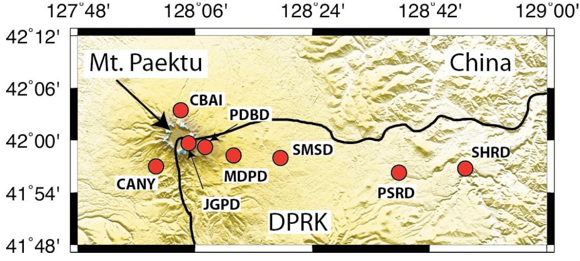
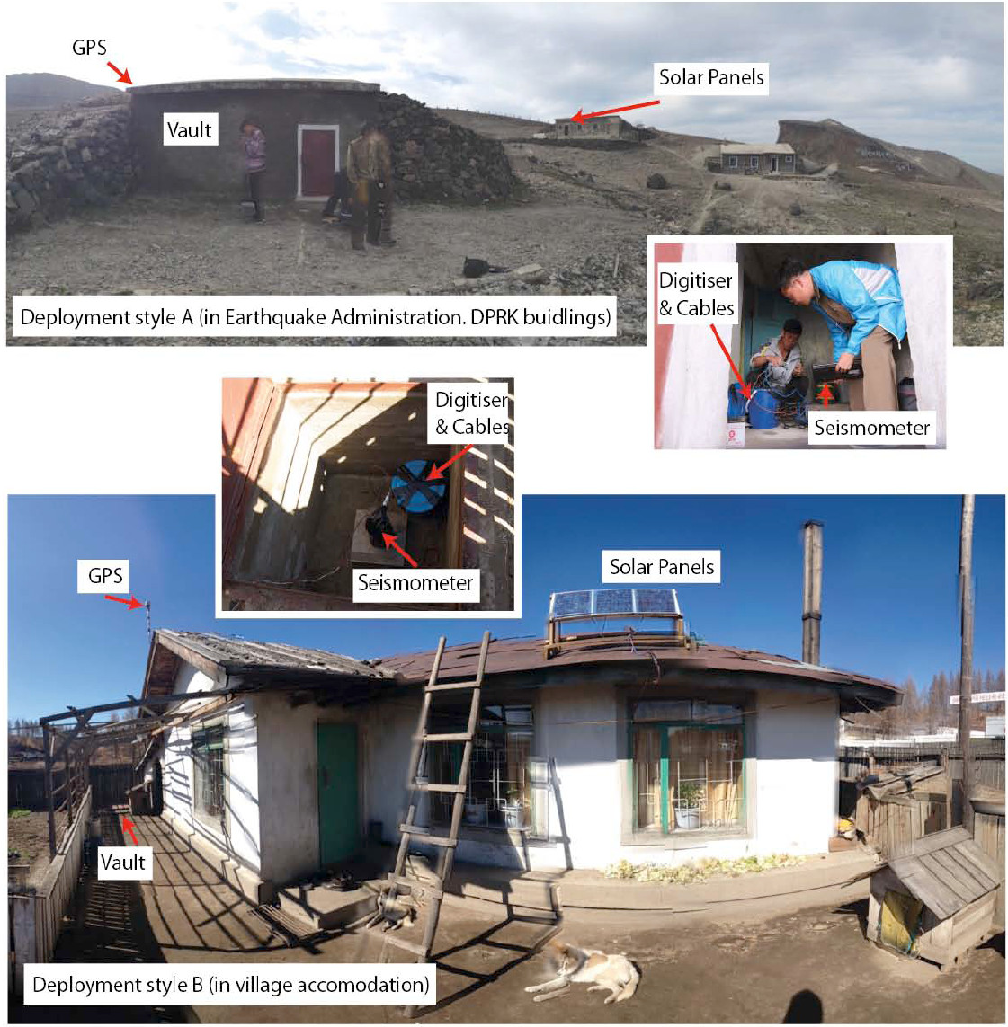
The 6 seismometers were deployed in a linear profile starting at the caldera wall and extending ~60 km almost directly east (Figure 1, Table 1). These sites were chosen in collaboration with the Earthquake Administration, DPRK to look at how the crust varies as you move away from the volcano and for ease of access. The three stations closest to the volcano (JGPD, PDBD and MDPD) were deployed within Earthquake Administration owned buildings. However, no Earthquake Administration buildings were located beyond ~30 km, so the three furthest stations from the volcano (SMSD, PSRD and SHRD) were deployed in local village homes. All stations were deployed in purpose built vaults. In Earthquake Administration buildings these were in the form of structures above ground (style A in Figure 2) and in village homes these were in the form of submerged vaults (style B in Figure 2). Care was taken to make sure water could not enter the vaults as spring thaws of heavy snowfall could be an issue. The seismometer (wrapped in a plastic bag, levelled and aligned with true north), digitiser, break out box and associated cables were stored in the vault with GPS located nearby. Due to the harsh winter conditions (temperatures reach -40°C in winter), it was decided to place solar panels on top of nearby buildings and batteries inside the buildings. This allowed the Earthquake Administration or local Korean families to look after the equipment and keep the batteries warm.

Issues
The requirement to host the solar panels and battery far from the seismometer created some issues. The power cables and solar panel cables to the regulator are small meaning they required extending in the field. Flexibility on cable length would be desirable. Additionally, a wrongly wired flying cable caused us to blow a number of fuses during deployment meaning no spares were available for the first few months of the project (luckily, there was no further fuse trouble until later in the project when replacements were available). Conditions at Jang Gun Peak (JGPD), the station at the caldera wall could be quite extreme. The main challenge was the extreme winds and cold temperatures. The former meant that solar panels could only be deployed on calm days meaning limited capacity to charge batteries, some times for periods of weeks. A small generator was supplied as an emergency backup. The cold temperatures also meant servicing was difficult, and the long download times for ESP meant this often had to be neglected during winter months. Other data loss was down to human error in backing up the data (JGPD, PDBD) or changing settings on the digitisers (PSRD). However, data recovery was reasonable and improved throughout the deployment.
Data quality
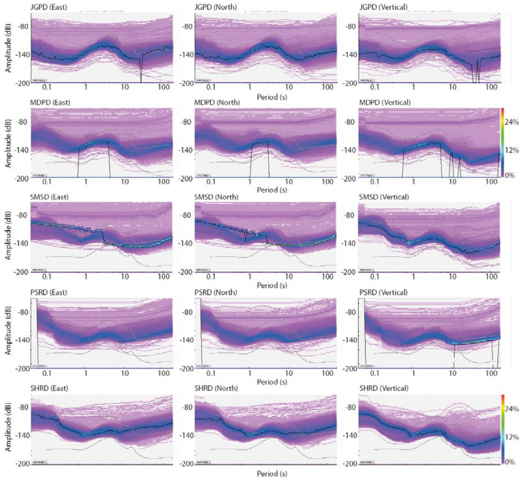
Data quality is excellent, largely due to the excellent vault construction led by the Earthquake Administration, DPRK and the lack of cultural noise (Figure 3). Vertical components show low noise levels for the periods of interest (1-60 s), but horizontal components show some higher noise levels at long periods, possibly due to the fact that stations were not buried. It may be worth burying the sensors in a sand filled bucket for future deployments (this also may help with cold temperatures). One note is that the 40T station (PSRD) has noticeably worse performance than the ESP stations at longer periods. This means that it may be more difficult to perform some teleseismic techniques using this and the station at PDBD.
Processing
Data were processed and archived using the standard SEISUK procedures. To date, receiver functions have been estimated using the extendedtime multi-taper receiver function technique (Helffrich, 2006). We plan to also conduct shearwave splitting (e.g., Wustefled et al., 2010) and invert receiver function anisotropy (Hammond, 2014). All data is shared with our colleagues at the Earthquake Administration, DPRK and is being incorporated into their earthquake location algorithms.
Interpretation & Preliminary findings
Crustal Structure
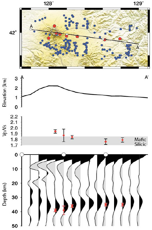
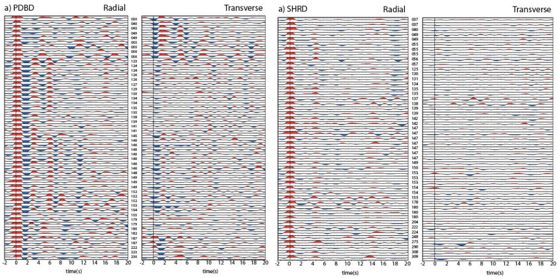
A receiver function analysis of the first year of data was performed during a research visit of 3 DPRK scientists to the UK (2 from the Earthquake Administration and 1 from the State Academy of Science) and a translator from PIINTEC in March 2015 (see Kyong-Song et al., 2016 for details). The first observation is that receiver functions at the easternmost extent of the array are simple, while those beneath the volcano are more complex (Figure 4), suggesting that magmatism at the volcano has significantly altered the crust. An H-κ stacking analysis (see Zhu and Kanamori for details of the technique) of these data provided further evidence for this with a thicker crust with a higher bulk VP/VS present beneath the volcano than those stations far from it (Figure 5). From this evidence we proposed that significant partial melt must be present beneath the volcano today and that a wide region away from the volcano has been modified by Paektu volcanism (Kyong-Song et al., 2016). We developed this further by performing common conversion point migration (see Hammond et al., 2011 for details of the technique) to look at more detailed lateral and internal crustal variations. These show a crustal thickening, but also show evidence for a mid-crustal velocity decrease at ~10 km (Figure 5). This is approximately the depth suggested for shallow melt storage regions associated with recent deformation (Xu et al., 2012) and past eruptions (Wei et al., 2013).
Ongoing work
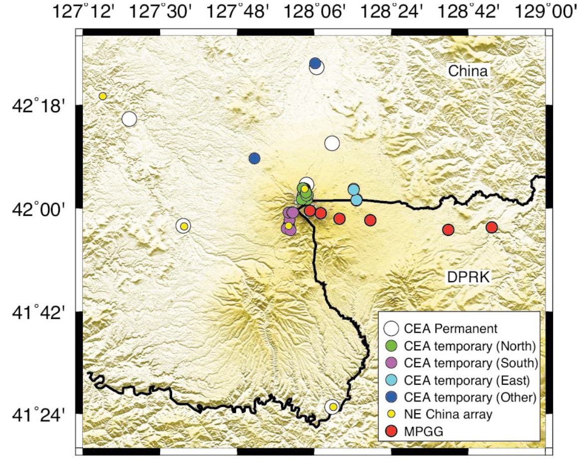
We are currently adding in the 2nd year of data and combining this with data from China (Figure 6). This will allow us to further constrain our results to date and provide more details on the spatial extent of melt and modified crust. Also, the longer time period will allow us to model anisotropy through investigations of back-azimuthal variations in the data. In August 2016 we held a workshop in Pyongyang with 12 international scientists (including 3 from China) and over 40 DPRK scientists. Here we discussed building on our project with a crossborder project to allow us to use these data as part of larger seismic projects, including tomography and other methods. We plan to develop this through more formal agreements over the next 12 months.
Conclusions and recommendations
The GEF loan has led to the collection of an exceptionally high quality dataset in DPRK. These are the first broadband seismometers ever deployed in the country. Through a visit from 3 DPRK scientists to the UK in 2015 we performed a receiver function analysis that shows significant amounts of melt are present beneath the volcano today (Kyong-Song et al., 2016). We are continuing this analysis, incorporating data from China to increase the spatial resolution as well as modelling the RF waveforms and investigating anisotropy in the dataset. We are building on this to develop new projects involving DPRK and Chinese scientists to incorporate data on all sides of the volcano.
Publications
Publications using these data have been highlighted in the reference list (in bold type). Other conference presentations describing the results have been made at international (e.g., Science Diplomacy 2015, Washington D. C., US), regional meetings in China and DPRK and there have been many public lectures and interactions with the international media.
References
Hammond, J. O. S., et al., (2011) The nature of the crust beneath the Afar triple junction: Evidence from receiver functions. Geochem. Geophys. Geosyst., 12, doi:10.1029/2011GC003738
Hammond, J. O. S. (2014), Constraining melt storage geometries beneath the Afar Depression,Ethiopia from teleseismic receiver functions: The anisotropic H-κ stacking technique, Geochem. Geophys. Geosyst., 15, doi:10.1002/2013GC005186.
Hammond, J. O. S. (2016) Engaging Diplomacy for Science: Understanding volcanoes in isolated locations, Science and Diplomacy, 5
Helffrich, G. (2006), Extended-time multi-taper frequency domain cross-correlation receiver function estimation, Bull. Seism. Soc. Am, 96, 344–347.
Horn, S., and Schmincke, H-U., (2000) Volatile emission during the eruption of Baitoushan Volcano (China/North Korea) ca. 969 AD. Bull. Volcanol. 61, 537–555.
Kyong-Song, R., et al. (2016) Evidence for partial melt in the crust beneath Mt. Paektu (Changbaishan), Democratic People’s Republic of Korea and China. Sci. Adv. 2, e1501513.
Oppenheimer, C., (2011) Eruptions That Shook the World (Cambridge Univ. Press, Cambridge, UK), 392 pp.
Peterson, J., (1993) Observation and modelling of seismic background noise, U.S. Geol. Surv. Open File Rep., 93–322, 1–95.
Song-Ryop, J., and Sin-Dong, K., (2008) Evaluation of determination accuracy of hypocentre localisation for earthquake occurring within Mt. Paektu. Geologic and Geographic Science 229, 13–14
Sparks, R. S. J., J. Biggs, and J. W. Neuberg (2012) “Monitoring volcanoes.” Science 335.6074 1310-1311.
Stone, R. (2011) Science 334:584– 588 Wei, H., Liu, G., and Gill, J., (2013) Review of eruptive activity at Tianchi volcano, Changbaishan, northeast China: Implications for possible future eruptions. Bull. Volcanol. 75, 706.
Wustefeld, A. et al., (2010), A strategy for automated analysis of passive microseismic data to image seismic anisotropy and fracture characteristics, Geophysics, 58, 755–773.
Xu, J., et al., (2012) Recent unrest of Changbaishan volcano, northeast China: A precursor of a future eruption? Geophys. Res. Lett. 39, L16305. Zhu, L., and H. Kanamori (2000), Moho depth variation in southern California from teleseismic receiver functions, J. Geophys. Res., 105(B2), 2969–2980.
