Scientific Report 990
This report is also available as a PDF document .
Abstract
Multiple lines of Ground Penetrating Radar (GPR) data were collected across drumlins in the upper Eden Valley Cumbria with the specific aims of determining the architecture of the drumlins and inter-drumlin “flats” and characterising the drumlin-substrate interface. The project was, for the most part, a proof of concept to demonstrate the utility of the technique for the investigation pf drumlin genesis. GPR lines were acquired using the Sensors and Software pulseEKKO 100 system using the 100 MHz, 50 MHz and 25 MHz antennae. Some repeat lines were acquired in order to determine the antennae which provided the best results. Site selection was made on presence of nearby bedrock outcrops, suggesting a shallow drumlinised diamict-bedrock contact with a clearly traceable horizon and a permeable lithology (limestone). Despite the clayey sediment and unfavourable weather conditions, a considerable penetration depth down to ~12 metres was achieved using the 50 MHz antennae, with a separation of 1 m, trace interval of 1 m and 128-fold vertical stack. Results indicate that the drumlinised diamict is in direct, contact with the bedrock. While the internal drumlin geometry is generally chaotic on the stoss side, evidence of down-flow dipping reflectors was found in the lee side. The inter-drumlin flats comprise ~4 metres of infilled sediment that masks part of the original drumlin profile. This study indicates that GPR can be successfully deployed for the study of subglacial bedform geometry and sedimentary architecture.
Background
Despite their widespread presence, and a three-century-long history of research (Menzies, 1984), drumlins remain amongst the most enigmatic landforms on Earth with many, formation theories having been formulated and in many instances still being debated (e.g. Boulton, 1987; Dardis, 1985; Hindmarsh, 1998). Understanding drumlin genesis is important because they are formed at the icebed interface, which exerts control on the dynamics of ice sheets and likely modulates their response to climate forcing (e.g. Kleman and Glasser, 2007).
Two key aspects of drumlin sedimentary architecture need to be resolved. The first is the relationship between the sedimentary body of drumlins and their substrate (e.g. bedrock). This is important because many theories, suggest that drumlins represent an accumulation/erosion of sediment around a nucleus/protuberance usually made of bedrock or less deformable sediment (e.g. Boulton, 1987; Dardis and Hanvey, 1994). The second relates to the nature of the inter-drumlin areas; are they primary features, so drumlins are blisters over a flat surface or, are they postglacial infills masking the original continuous sinusoidal surface (Spagnolo and others, 2012; Finlayson, 2013)?
A comprehensive study covering multiple aspects of the structure of drumlinised terrain, including a large number of landforms, is necessary for an improved understanding of drumlin formation. This cannot be achieved by investigation of outcrops alone, simply because they are too limited in number. GPR offers the potential for rapid data collection but its feasibility for the study of subglacial bedforms is yet to be fully tested.
The aim of this project was to test the application of GPR to the investigation of a number of drumlins in an attempt to elucidate:
(i) the relationship between drumlins and their substrate (ii) the geometry of inter-drumlin areas (iii) drumlin internal architecture
Environmental conditions are of extreme importance in the acquisition of GPR data, the success of which is therefore highly dependent on identifying favourable field sites. For this project, three criteria were adopted for the selection of the most suitable site:
- an easily accessible area rich in drumlins (for logistical reasons in this instance)
- a site characterized by shallow bedrock, so that the contact between the drumlinised sediment and the underlying bedrock is likely within the range of GPR penetration
- an area where the drumlinised terrain is well drained and there is a deep water table, because GPR signals are strongly attenuated below the water table
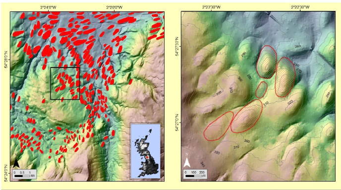
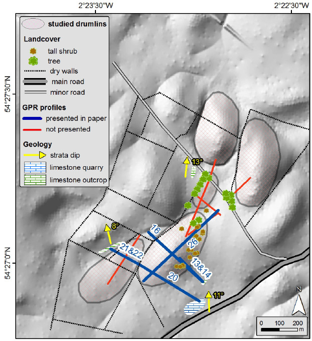
The field site selected for this work (Figure 1) is 3 km SW of the village Kirkby Stephen and at the SE end of the Eden Valley. The site contains a small quarry with a number of minor bedrock outcrops. The shallow bedrock should provide a clear reflector on the GPR allowing direct measurement (strike and dip) of bedrock structure. The lithology is Carboniferous limestone belonging to the Potts Beck Formation (British Geological Survey, 1997). The land cover is pasture, i.e. grass fields bounded by dry stone walls, with sparse trees and shrubs. Since some of these elements (e.g. walls) have an effect on GPR acquisition, they were mapped in the field and from satellite images (Figure 2). The literature on drumlins in this region (Mitchell and Riley, 2006), the British Geological Survey map sheet (England and Wales Sheet 40, 1997) and the analysis of nearby boreholes (British Geological Survey borehole records) all suggest that the drumlins are largely composed of diamict. This is supported by observation of a few small exposures in the field.
Survey procedure
Three antennae were deployed using 25, 50 and 100 MHz centre frequencies, in order to provide different depths of penetration and levels of vertical resolution. Initially, data were acquired using a 64 fold vertical stack but this was increased to128, improving the signal to noise ratio significantly. A differential Global Positioning System (dGPS) was used, real-time, to correct the GPR acquisition. To meet objectives i and ii above profiles were acquired approximately along and across the drumlin long axis. The cross-lines were not always perpendicular to the long axis because we wanted to image inter drumlin areas and also to tie into the bedrock exposures. 14 profiles were acquired totalling 3.4 km using varying set ups. A number of lines were repeated using different frequencies with the details of all provided in Table 1.
Processing and Modelling
The GPR data were processed using the following basic steps, with variations applied for different antenna frequencies.
- A time zero correction was applied to account for the delay caused by the antenna separation. For some lines this was constant, but for others the correction varied by between 5 and 10% due to the presence of grass tussocks or heather.
- A background removal step was applied to suppress the high-amplitude direct wave.
- A bandpass filter was applied to suppress low-frequency amplifier saturation effects and high-frequency noise.
- A gain correction was made to compensate for the spherical spreading of the radar wave which causes a reduction of reflection strength with depth.
- A number of profiles displayed a horizontal reverberative noise which was more common over rough ground with higher vegetation. This may be due to the antennae not being closely coupled to the surface, resulting in ringing between the body of the antenna and the ground. This noise was removed by the application of a horizontal filter.
- The data were migrated using a constant radar wave speed of 0.1 m/ns (Davis and Annan, 1989). Due to the variable penetration achieved and the undulating subsurface a successful common-midpoint (CMP) survey was not possible.
Data quality
Seven of the fourteen profiles resulted in particularly good quality data and are presented below. These are profiles # 13, 14, 16, 20, 21, 22 and 26 (Table 1). The remaining seven profiles were of poorer quality, either because the acquisition parameters were not ideal, or they were heavily impacted by the presence of nearby walls and roads, and by perched water tables (especially in the inter-drumlin areas).
Preliminary Interpretation
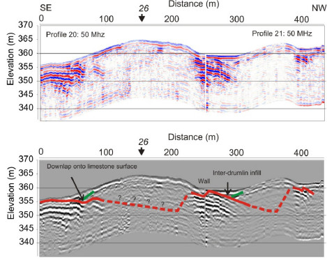
Drumlin/substrate relationship: A number of transverse and longitudinal profiles were acquired along lines beginning at a bedrock outcrop. Structural measurements from the outcrops allowed the calculation of the apparent dip that would be seen in a section at either end of GPR profile 20 and 21 (Figure 3). This gives a range of 4 to 6 degrees dipping to the NW. The apparent dip measured from the GPR profiles is 6 , thus supporting our interpretation that these strong reflectors are bedrock bedding planes. However, signal attenuation is still an issue and penetration beyond ~15 m was not possible.
Inter-drumlin areas: The inter-drumlin sediment is characterised by an overall wedge-like geometry, horizontal layering and is interpreted as post-glacial sediment reworking and infilling of the topographical lows located around the drumlin flanks.

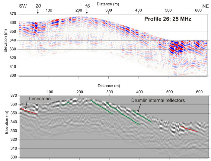
Drumlin internal architecture: On the longitudinal profile (Figure 4), it appears that beyond the zenith of the drumlin, internally, there are a series of downflow dipping layers. The dip angle of the layers is greater than both the surface slope of the drumlin and the dip of the limestone bedrock. This is interpreted as evidence for progressive accumulation of sediment in the lee side, while the stoss side is characterised by more chaotic sediments (as evinced by a chaotic radar facies), an arrangement that resembles that of a lee-side cavity-
Conclusions and recommendations
Profiles 13, 14 and 16 were all recorded on the south-eastern flank of the central drumlin (Figure 2). This is an optimal situation where the interface between the sediments comprising the drumlin and inter-drumlin areas and the limestone bedrock should all have very different radar responses.
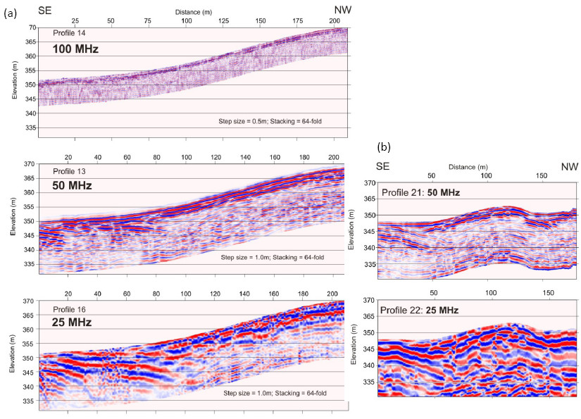
Profile 14 (Figure 5a) was recorded using 100 MHz antennae, with a separation of 1 m , nominal trace spacing of 0.5 m and a 64-fold vertical stack and failed to produce useful results in this setting due to poor signal penetration (the sediment-bedrock interface cannot be imaged through sediment exceeding ~ 2 m).
Profile 13 was recorded with 50 MHz antennae, with a separation of 2 m, nominal trace spacing 1 m and 64-fold vertical stack This profile shows a strong reflection dipping left to right between trace numbers 1 to 90; similar to profile 20 (Figure 3). Bearing in mind that the profiles started at a bedrock outcrop, the dipping reflectors are interpreted as the sediment-bedrock interface and bedding planes.
Profile 16 was recorded with 25 MHz antennae, with a separation of 4 m, nominal trace spacing of 1 m and a 64-fold vertical stack. This profile also shows a strong reflection where the bedrock is expected to dip beneath the drumlin. The reflection has good lateral continuity but, in common with all other reflections on the record, it is highly reverberative which makes it more difficult to determine the location of the sediment-bedrock interface.
It is clear from these three profiles that the best compromise between penetration and resolution, in this particular setting, was the 50 MHz antennae. Further confirmation of this is provided by comparison between Profiles 21 and 22 (Figure 5b). These were acquired as cross-lines over the westernmost drumlin (Figure 2). The acquisition parameters were the same as Lines 14 (50 MHz) and 16 (25 MHz) except that the vertical stacking was 128-fold. The additional stacking produces records with an even higher signal-to-noise ratio, so that internal reflectors are clearer. However, acquisition time is longer which was of no issue for this study but may have implications if a vehicle mounted/towed operation is planned.
All three objectives outlined in the introduction were, at least in part, achieved, with a significant penetration depth reached (>12 m based on the adopted velocity model). This work revealed that the sediment-landform assemblage has three main components: the drumlinised diamict, the bedrock substrate and the inter-drumlin infill. Wherever the bedforms were imaged, no intermediate sediment between the drumlinised diamict and the bedrock substrate was detected, thus suggesting that the entire volume of available sediment in the system was involved in the drumlinisation process. Further details of the processing and interpretation can be found in Spagnolo et al (2014).
References
Boulton GS (1987) A theory of drumlin formation by subglacial sediment deformation. In Rose J and Menzies J eds. Drumlin Symposium. A.A. Balkema, Rotterdam, 25-80
British Geological Survey, 1997. Kirkby Stephen. England and Wales Sheet 40. Solid and Drift Geology.
Dardis GF (1985) Till facies associations in drumlins and some implications for their mode of formation. Geogr. Ann. A. 67(1-2), 13-22
Dardis GF and Hanvey PM (1994) Sedimentation in a drumlin lee-side subglacial cavity, northwest Ireland. Sediment. Geol., 91, 97-114 (doi: 10.1016/0037-0738(94)90124-4)
Davis JL and Annan AP (1989) Ground-penetrating radar for high resolution mapping of soil and rock stratigraphy. Geoph. Prospecting, 37(5), 531-551 (doi: 10.1111/j.1365-2478.1989.tb02221.x)
Finlayson A (2013) Digital surface models are not always representative of former glacier beds: palaeoglaciological and geomorphological implications. Geomorph., 194, 25-33 (doi: 10.1016/j.geomorph.2013.03.026)
Hindmarsh RCA (1998) Drumlinization and drumlin-forming instabilities: viscous till mechanisms. J. Glaciol., 44(147), 293-314
Kleman J and Glasser NF (2007) The subglacial thermal organisation of ice sheets. Quat. Sci. Rev., 26, 585-597 (doi: 10.1016/j.quascirev.2006.12.010)
Menzies J (1984) Drumlins: A Bibliography. Geo Books, Norwich. 117 pp. Mitchell WA and Riley JM (2006) Drumlin map of the western Pennines and southern Vale of Eden, northern England. J. Maps, 2006, 10-16 (doi: 10.4113/jom.2006.45)
Spagnolo M, et al. (2012) Drumlin relief. Geomorphology, 153-154, 179-191 (doi: 10.1016/j.geomorph.2012.02.023)
Spagnolo, M. et al, (2014) Looking through drumlins: testing the application of ground penetrating radar. J. Glaciol., 60(224), 1126-1134 (doi: 10.3189/2014JoG14J110)
