
Scientific Report 970
This report is also available as a PDF document .
Abstract
Understanding the development of bedforms in coarse gravel deposits is important for hydro-geological, engineering purposes and for the interpretation of ancient sedimentary sequences. Coarse-gravel bedforms in the Altai area (Siberia), which result from Pleistocene glacial outburst floods have been identified as sub-aqueous dunes. GPR surveys of several dunes have elucidated the internal structures. Sediment analysis and stratigraphic mapping of sections has been used to calibrate the characteristic radar facies pattern. A striking feature is the continuous, subhorizontal reflections in the GPR profiles, in section parallel to the palaeoflow. These reflections separate sets of inclined reflections, which are identified as cross-sets consisting of alternate layers of bimodal and well-sorted open-framework gravel. The steeper reflection cross-sets are interpreted as indicative of avalanching processes on steep dune lee-sides, whereas low angle reflectors represent the sorting process associated with deposition of bedload sheets on low-angle dune lee-sides or on the back of the stoss-side. The geometry of the continuous reflections distinguishes different distinct sets of superimposed gravel cross-beds. This structure is interpreted as representing the unsteady downstream migration of 2-D dunes, about 2 m high in an aggrading setting.
Background
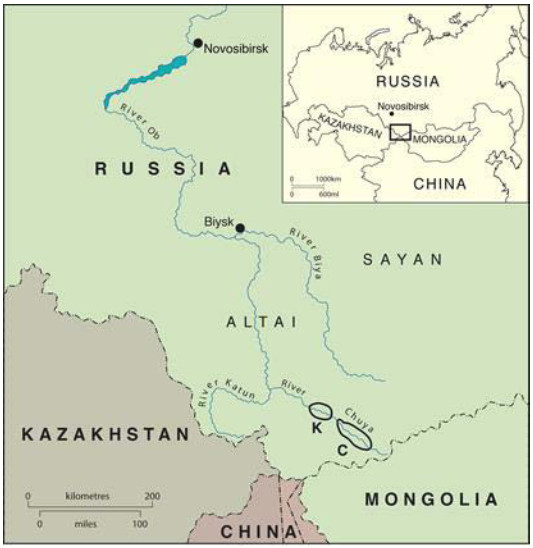
Landforms of flood origin resulted from late Pleistocene ice-dammed lake failures in the Altay Mountains of south Siberia. The suite of landforms represent flood processes similar to those responsible for the Channelled Scabland in the north-western United States which originate from the failure of ice-dammed Glacial Lake Missoula. The peak discharges of these floods where in the order of 17x106 m3 s-1. As a consequence a distinctive suite of landforms is associated with the immense stream power of such flooding. Cataclysmic flood landforms in the Altay Mountains (Siberia) include: flood-scoured gorges, giant bars rising 200 m above Katun River and Chuja Rivers, and large gravel dunes. In the Chuja and Katun river valleys (headwaters of river Ob) a sequence of dune fields consisting of steep individual gravel dunes developed subaqueously at localities in the Kuray Basin (Fig. 1). The mobilisation of coarse gravel to develop pronounced dune-topography requires high shear stresses and great depths. As such flows are rare there are few published studies of steep gravel dunes. Comparisons of the morphology of these “fossil” dunes structures with modern dunes lead to the conclusion that the form of 2-D transverse dunes and 3-D cuspate and lunate dunes developed in coarse gravels is comparable with sand-dune morphology within lesser-scale geophysical flows.
The dune forming mechanism initially could only be derived from morphological analysis of the dune geometry, and a limited number of shallow trenches. In sections cut 2 m high in 3D ‘barchanoid’ dunes, swaley bedding and several cross-bedded units were recorded, but it was not possible to elucidate the detailed stratigraphy. In similar sections cut 2 m high in 2-D transverse dunes several planar cross-bedded units were recorded. These sedimentary facies data provide calibration of the radar facies. The advantage of using GPR over manual pit surveying, is that it is non-destructive and provides extensive transects with 15 m depth penetration. In this manner the spatial variation in dune stratigraphy can be portrayed in some detail, calibrated against the logged sections in trenches.
Survey Procedure
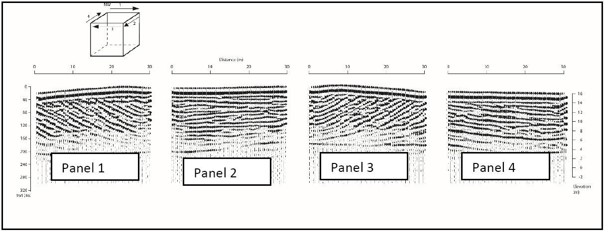
In 2012, a ground penetrating radar (GPR) and topographic survey was made of the largest, 16m high asymmetric ridge of wavelength 180m. GPR data collection used a Pulse Ekko Pro GPR system with a 1000 volt transmitter, a 350 nanosecond time window with 0.25m step size, 100MHz and 200MHz antennae with 1m separation and 32 stacks at each location. Five longitudinal profiles, each 10m apart and running parallel to the direction of palaeoflow, east to west, were collected over the highest dune (Fig. 2). These profiles were run in an upstream direction from c. 8m downstream of the lee toe of the dune to c. 8m upstream of the stoss toe. Two flow transverse profiles were also obtained along the crest of the dune. In addition, an extended profile over seven dunes was obtained parallel to the original five survey lines (Fig. 3). The common mid-point procedure was used along transverse profiles above horizontally bedded sediments to obtain the near-surface velocity. The 200MHz data produced poor results and are not reported herein as the data were not retained. The 100MHz data had not reproduce the lower central portion of the dune very well in 2010 but better results were obtained in 2012 by increasing the time window and reducing the number of stacks (see 5): this limitation did not compromise the interpretation. 50MHz antennae were also used to try to improve the resolution of the radar stratigraphy in the core of the dune but the results were not significantly better than was obtained using the 100MHz data and these data also were not retained. Between two parallel profiles on a dune crest two short transverse profiles were surveyed to produce a 30x20m `box’ section plot. All profile lines were surveyed to define the topography using a Geodimeter total station. Approximate georeferencing of profile terminations was accomplished using a Garmin hand-held global positioning system.
Data quality
Data quality is extremely good with little or no noise because the area is very remote and free from external electromagnetic radiation and there are few tree roots. The GPR successfully imaged sets of cross-stratification within the dunes as well as the basal contact and internal bounding surfaces. Checks of dip and strike orientation have been conducted using a 30x30m box on the crest of the first dune.
Processing and modelling
The antennas were arranged in the parallel broadside configuration spaced 1m apart and moved with a step size of 0.25 or 0.5m along tape measures laid on the ground. The time window used for the surveys was initially 260ns but this was later increased to 350ns because 260 ns was barely sufficient to image the base of 16m high dunes. At the same time the number of stacks was reduced from 64 to 32. Data processing includes Dewow, AGC gain (max 200), trace to trace average 2, and down the trace average 2, followed by migration, tilt and topographic correction using a velocity of 0.135m/ns estimated from curve fitting calibration with diffraction hyperbolas as well as a common mid-point survey collected along the crest of one of the dunes.
Interpretation
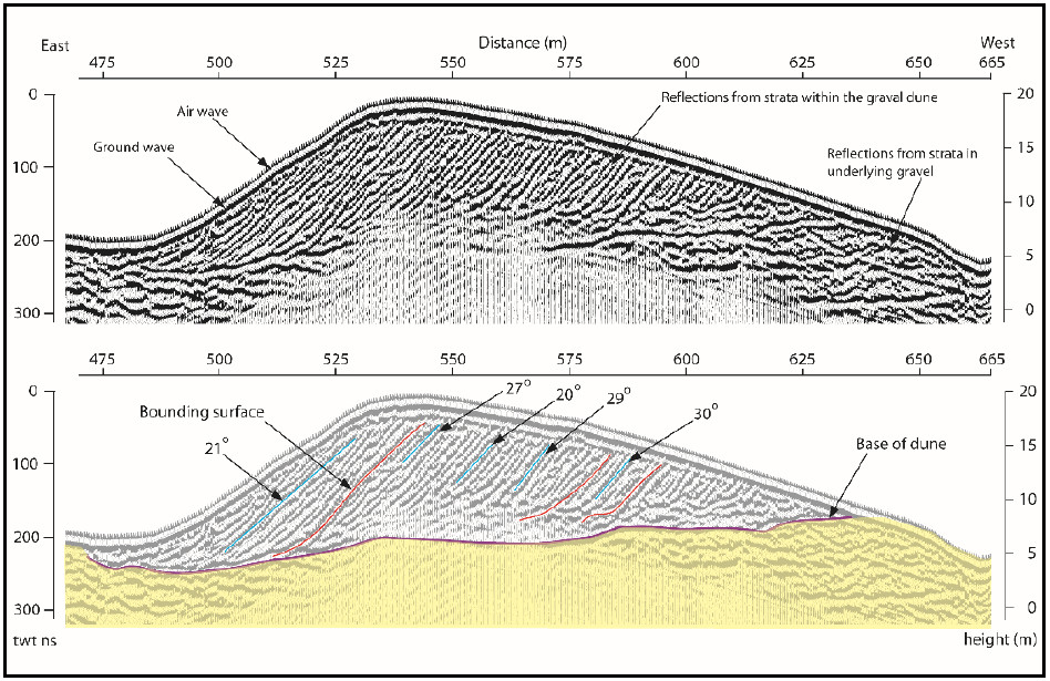
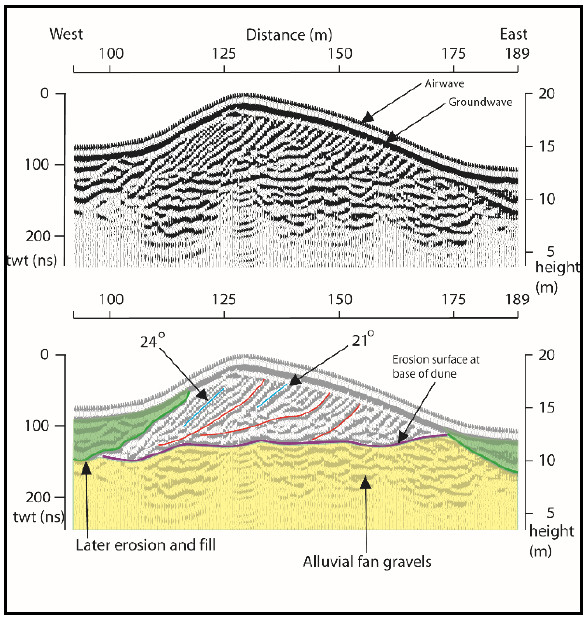
The GPR profiles reveal details of the dune strata that record the dune development, migration and some later modification. The radar reflections from within the dunes are dominated by inclined reflections that dip from right to left (Fig. 4) at between 20 and 30 . These inclined reflections are interpreted as sets of cross-strata. The cross-strata are both planar and tangential. Bounding surfaces that truncate some reflections and are in turn down-lapped by overlying reflections dipping in a downstream direction are common but the arrangement of the bounding surfaces and the packaging of the strata that they divide varies between dunes. At the base of each dune is an erosion surface that dips downstream. The basal erosion surface of the upstream dune cuts down 5m into the underlying strata indicating that scour in the lee of the bedform increased as the dune developed. A GPR profile along the crest line shows that some of the strata are planar tabular but others are slightly convex or concave in sympathy with the dune planform which is largely straight crested but with some lobes and saddles. At the lobes the strata bow downstream and at the saddles the strata bow upstream.
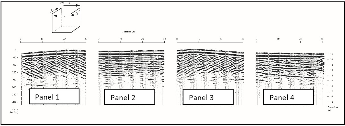
The radar reflections within the dune are dominated by inclined reflections which dip from right to left in a downstream direction. These inclined reflections are interpreted to be from cross-stratification within the dunes. At the base of the dune is a sharp but irregular reflection interpreted as a basal erosion surface. Reflections from cross-strata downlap onto this surface as the dune migrated downstream. Within the inclined reflections there are lower angle inclined reflections that truncate underlying reflections and are in turn downlapped by overlying reflections, these surfaces are interpreted as bounding surfaces where there has been a break in deposition a with a reshaping of the dune bedform. The packages of cross-strata separated by bounding surfaces indicate a vertical stacking of strata within the dune not just a simple downstream translation of a migrating bedform (Fig. 5). This assemblage could be a response to a rapidly changing flood hydrograph where the bedform wavelength and height tries to adjust to the fluctuating discharge. The rising limb of the hydrograph is marked by the basal scour and initial dune construction. During peak discharge the giant dune is formed and this migrates downstream generating sets of crossstrata. As the discharge declines and flow depth decreases smaller dunes (Fig. 6) are formed but their development is constrained by the existing giant dune morphology so the small dunes generate bounding surfaces and smaller sets at the crest and downstream margins of the giant bedforms. The presence of regular tabular cross-beds of approximately equal spacings, especially developed on the stoss side, implies steady progression of the dune in relatively weak flows with an intermittent supply of self-similar quantities of gravel to the brinkpoint. In contrast, in the crestal region, and in the lee, cross-bedding is less regular and includes beds that may thicken or thin towards the base.
Conclusions and recommendations
GPR images the internal structure of very coarse grained giant dunes. The dunes appear to have formed under the rising limb of a hydrograph and rapidly abandoned. This interpretation is consistent with increasing bed shear stress during catastrophic drawdown of a rapidly draining lake basin. This interpretation is supported by modelling of basin scale flood events.
Acknowledgements
The Royal Society of London is thanked for grant aid.
Presentations and publications
2013: Oral presentation at the 8th Symposium on River, Coastal and Estuarine Morphodynamics, RCEM , Santander, Spain ‘Radar Stratigraphy and Hydraulic Interpretation of Megaflood Gravel Dune’ GEF loan 970
2013: Oral presentation at the 10th International Conference on Fluvial Sedimentology ( ICFS 10), Leeds, UK ‘New insights into megaflood gravel dunes from GPR surveys, Altai Mountains, Siberia’ GEF loan 970
Carling PA, Bristow CS, Litvinov AS. 2016. Ground-penetrating radar stratigraphy and dynamics of megaflood gravel dunes. Journal of the Geological Society, doi:10.1144/jgs2015-119. GEF loan 970 (2012) and 931 (2010)
Bohorquez, P., Carling, P.A., Herget, J., 2015, Dynamic simulation of catastrophic late Pleistocene glacial-lake drainage, Altai Mountains, central Asia. International Geology Review, DOI: 10.1080/00206814.2015.1046956.
Instruments deployed
1) Geodimeter Serial no. 60830689 (University of Southampton)
2) GPR equipment (GEF loan 970)
-
Sensors and Software PulseEKKO 100A,
-
Console V2.9 Serial No. 001006180018
-
Receiver v2.13 Serial No. 001101970002
-
Transmitter v1.12 Serial No. 001202840015