Scientific Report 920
This report is also available as a PDF document .
Abstract
Airborne laser scanning (ALS) and digital spectral data were collected by the NERC Airborne Research and Survey Facility (ARSF) for an area of 12km2 centred to the south east of Upavon, Wiltshire, with the purpose of enhancing the understanding of the use of multisensor survey for prospection and analysis of archaeological remains. The area lies on the East Range of Salisbury Plain Army Training Area and was selected for the study due to the quantity of archaeological remains in varying states of preservation. The project was supported by equipment loans from the NERC Geophysical Equipment Facility (GEF) and Field Spectroscopy Facility (FSF). The Leica 1200 GPS system borrowed from the GEF was used as a base station for the aerial data collection, to locate the areas for simultaneous geophysical prospection and to provide ground control points to assess and improve the accuracy of the Digital Elevation Model (DEM).
Background
Airborne remote sensing has long been recognised as a vital tool for prospection of sites of archaeological interest. Initially prospection was carried out solely via aerial photography, but increasingly other sensor platforms are being brought into play to seek out previously undiscovered archaeological remains or add detail and coherence to our understanding of known historic landscapes (Bewley et al. 2005)1. While results from the use of digital remote sensing technologies such as digital spectral and ALS data acquisition have been promising, our scientific understanding of how to apply these technologies is in its infancy. Many techniques, such as the Normalised Difference Vegetation Index (NDVI), are taken directly from environmental science, often with little regard for their original purpose or the suitability of their application to archaeological studies (Bennett et al. 2011)2.
The success of remote sensing for archaeology is often measured simply in terms of the quantity of new features identified. However as our understanding of how archaeological deposits are represented in remotely sensed datasets has never been systematically tested, the biases caused by factors such as variations in season, soil type, vegetation cover and land use limit the feasibility of a purely quantitative approach. Furthermore, knowing a feature can be identified under certain conditions is of little assistance when attempting to judge the value of the deposit or its state of preservation.
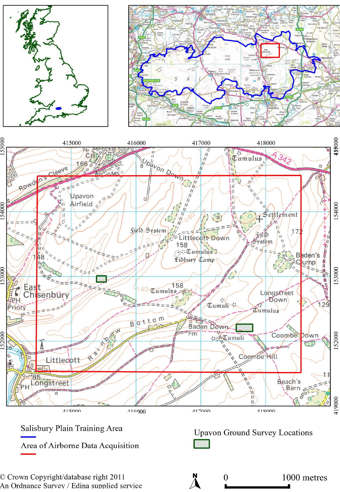
The aim of the project established at Bournemouth University in 2008 is to more precisely understand the physical, chemical, biological and environmental factors that play a significant role in the visibility of sites in airborne remotely sensed data. The research seeks to advance the field of remote sensing for archaeology by systematically developing and testing techniques for processing a range of remote sensing data and combining the results with ground based and subsurface data, thus improving our understanding of the role of remote sensing in determining the nature of archaeological features observed. A key development of the project in 2010 was the opportunity to collect ground observations, including ground spectral, earth resistance and ground penetrating radar (GPR) survey along with soil samples simultaneous to the acquisition of tailored ALS and hyperspectral survey by the NERC ARSF providing a unique stack of data to assess the quality and inform the interpretation of the airborne data. Figure 1 shows the location of the Upavon study area.

Survey Procedure
The GEF Leica 1200 GPS was deployed in advance of the flight date to establish the grid locations for the geophysical survey. On the day of the airborne acquisition, (4th March 2010) the GPS was used as a base station providing continuous recording of positional data with which to calibrate the airborne GPS as there were no OS base stations within 30km of the site. Due to this, the deployment of the GEF GPS was critical to the accuracy of the airborne survey, allowing the processing of the ALS data with high spatial accuracy.
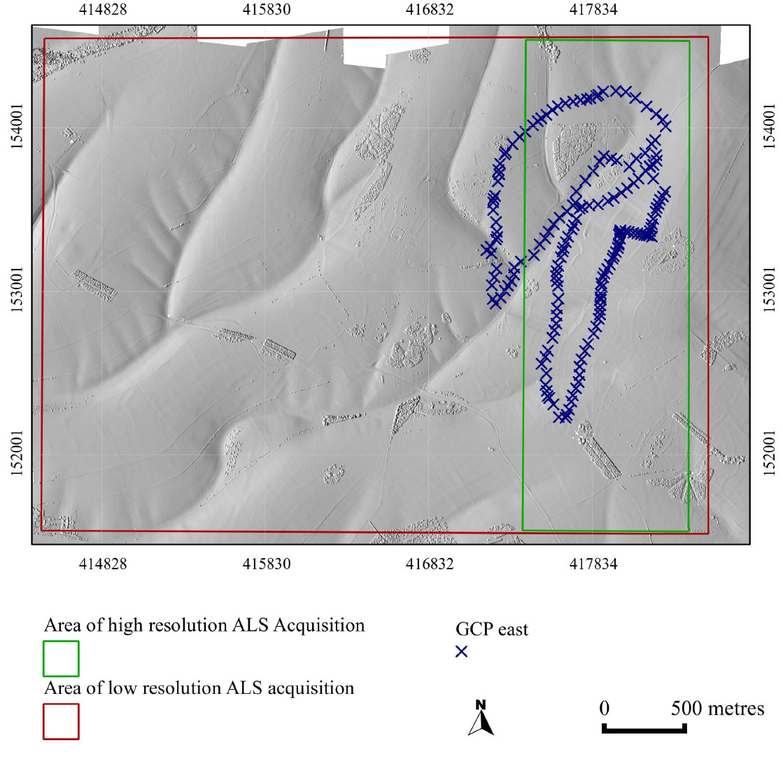
The ALS data were collected to two specifications. The first coverage of the whole study area was defined principally by the optimal flight height for the simultaneous hyperspectral data collection. The second coverage was a repeat flight of a transect in the eastern part of the study area with flight height specified so that the maximum resolution of data could be achieved within the limits of the operating platform and sensor.
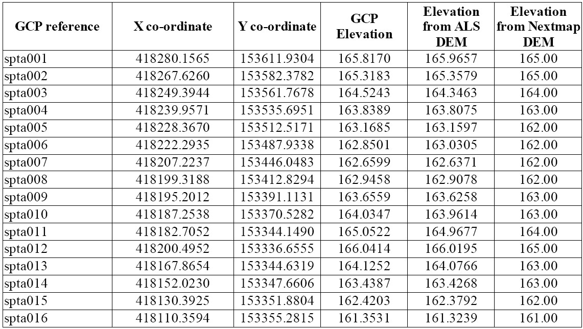
To test the accuracy of the ALS DEM, the measurement of numerous ground control points (GCPs) to an accuracy of ±0.05m was subsequently undertaken. In all, 177 3D point locations were recorded across the landscape in the area of high resolution ALS acquisition as shown in Figure 2.

Processing and modeling
The data from the base station was geometrically located using RINEX data and forwarded to ARSF Processing for inclusion in the ALS processing. The GCP data were also corrected using RINEX data from Ordnance Survey antennae and converted to OSGB36.
The ALS data were strip adjusted using the least-squares matching technique (LSM), cleaned and filtered using OPALS3 and processed into a DEM using GRASS. The GCPs were exported to a vector file with x, y and z attributes. The height data were then extracted from the DEM at the GCP locations and exported to a spreadsheet for the calculation of the RMSE.

Data quality
In the area of high resolution data where the ALS resolution was 9.2 hits per m2, the DEM was found to have a elevation accuracy of ±0.10m.

Interpretation to date
Interpretation to date The initial results appear to show a significant improvement in DEM quality from the use of repeat ALS survey. They also show that the OPALS LSM method for strip adjustment is highly effective for high resolution data.
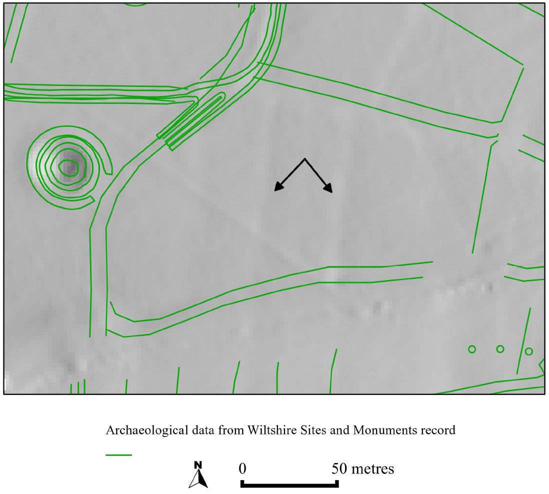
The high quality DEM also shows a significant improvement for the aerial prospection of archaeological features when compared with the baseline data collated from archive aerial photographs and held by the Wiltshire Sites and Moments Record. Figure 3, an overlay of the previously recorded archaeological features and the ALS hillshaded model shows two additional north south lynchet features in this field system.

Primary findings
The high quality DEM can be used as a basis for the geocorrection of the hyperspectral data offering a significant improvement on the ±0.67m RSME of the Nextmap 2m resolution DEM. The higher vertical accuracy also makes it suitable for processes such as Local Relief Modelling that aid the identification and recording of subtle archaeological features (Hesse 2010)4.
Conclusions and recommendations
Work on the airborne remotely sensed data is still very much in progress, but preliminary quality analysis of the ALS and GCP data has indicated the following broad conclusions:
- The spatial distribution of GCPs in the area of high resolution data was adequate for detailed assessment of the accuracy of the ALS model.
- Repeated but temporally contemporaneous ALS acquisitions of the same area have been shown to be extremely useful in creating high-resolution, high accuracy models within the constraints of the operating platform and sensor.
- The use of LSM routines provides a clear method for strip adjustment for ALS data which retains spatial and vertical accuracy, even in areas of undulating rural landscape.
Recommendations include:
- Collection of spatially distributed and high accuracy GCPs across the ALS acquisition area as the key method for analysis of the accuracy of the DEM.
- The use of LSM routines for strip adjustment
- The recognition of the impact and limitations of working in areas of high radio frequency interference when undertaking dGPS survey.
Publications (including proposed, in preparation, submitted, in press and published)
Bennett, R., Welham, K., Hill, R.A., and Ford, A. 2011. Making the most of airborne remote sensing techniques for archaeological survey and interpretation. In D. Cowley (ed.) Remote Sensing for Archaeological Heritage Management.EAC Occasional Paper, 99-107. Hungary: Archaeolingua
Conference Papers
Bennett, R., Welham, K., Hill, R.A., and Ford, A. 2010a. Analysing the Vegetation Information Content of Airborne Remotely Sensed Data with Respect to Improving Understanding of Archaeological Features. In Cork, Ireland
Bennett, R., Welham, K., Hill, R.A., and Ford, A. 2010b. Multisensor Airborne Remote Sensing Techniques for Archaeological Survey and Interpretation. In Bucharest, Romania
Proposed Papers
Further publications are planned for 2011 in journals covering both archaeological and remote sensing special interests but these are still in the outline stages.
References
-
Bewley, R.H., Crutchley, S.P., and Shell, C.A. 2005. New light on an ancient landscape: Lidar survey in the Stonehenge World Heritage Site. Antiquity 79(305): 636-647. ↩
-
Bennett, R., Welham, K., Hill, R.A., and Ford, A. 2011. Making the most of airborne remote sensing techniques for archaeological survey and interpretation. In D. Cowley (ed.) Remote Sensing for Archaeological Heritage Management. EAC Occasional Paper, 99-107. Hungary: Archaeolingua ↩
-
Developed by TU Wien, http://www.ipf.tuwien.ac.at/opals/opals_docu/index.html ↩
-
Hesse, R. 2010. LiDAR-derived Local Relief Models - a new tool for archaeological prospection. Archaeological Prospection 18(2). ↩
