Scientific Report 1154
This is a Reduced Scientific Report resulting from our minor loan scheme.
Summary
This loan supported a methodological study which examines the potential of lightweight (<250g) drones such as the DJI Mini 2 towards creation of digital elevation models (DEMs) using Structure-from-Motion (SfM) photogrammetry, by comparing its output vis-à-vis the one obtained from images captured by the DJI Phantom 4, which is a bespoke surveying/photogrammetry drone. The loaned GNSS equipment was instrumental in this project as high accuracy ground control points (GCPs) are required to orthorectify and assess the accuracies of the created DEMs.
Besides the equipment loan, the excellent support provided by NERC GEF team was an incredible help in ensuring the required work was carried out to a high standard.
Research facilitated by this loan
The spatial resolutions of the many open-source global digital elevation models are too coarse for fine-scale geomorphological monitoring and analyses, underlining the necessity of high-resolution elevation surfaces. However, procuring analysis-ready high-resolution DEMs remains an expensive affair. Therefore, the central motive of this project is to ascertain ways in which high-resolution elevation modelling can be more democratised.
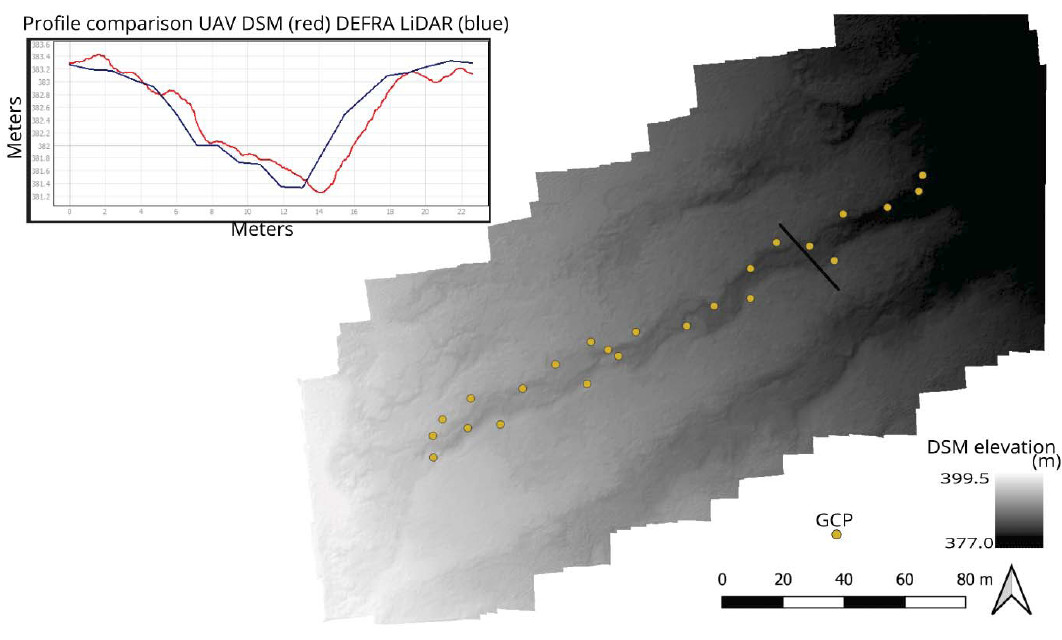
This project has two components, one relating to aerial photogrammetry and the other pertaining to groundbased approaches to DEM creation. The GNSS loan aided in the aerial photgrammetry survey, which was undertaken at a gullied catchment in the upland peat at Holcombe Moor (NE of Bolton). We set up the base station on the plateau top and then collected the GCPs at various landscape positions on the adjacent gullied hillslope. The two drones were then flown at a height of 50 m. The resulting SfM DEM was comapred to a freely available DEFRA LiDAR 1m DEM to evaluate whether gully morphology was adequately captured using the SfM method compared to LiDAR (which is not always available globally).
Additionally, as part of the ground-based component, we scanned a few gully cross-sections using the iPad Pro LiDAR sensor. More ground survey works required for this project will be undertaken in India this coming winter. We will be comparing SfM DEMs processed from ground photographs (captured using a standard digital camera) with that produced by the iPad Pro LiDAR scanner.
Survey Methodology and Data Processing
Static survey method, using a base station and rover, were used to collect the GCPs. Post-processing was carried out in the Leica Infinity program. The base station was corrected to OS net RINEX data from the nearest station to the study site. The rover points then adjusted to the corrected base. Corrected points had an accuracy of ±0.02m based on repeat point measurements taken.
SfM photgrammetry was perfomed in Agisoft Metashape Professional. 6 points were used for orthorectification. 24 GCPs were used to evaluate accuracy of the photogrammetric DEM. A SfM DEM with 0.29m (±0.02) root mean square error elevation error was produced.
Project Outcomes
The GNSS equipment was essential for orthorectification of the imagery taken, allowing more accurate comparison with the LiDAR product.
The UAV derived DEM was similar to the LiDAR DEM in capturing gully depths and morphology. A slight offset in absolute position in gully walls is noted, likely due to differences in orthorectification. The calculated vertical accuracy of the DSM (0.29 ± 0.02m) is similar to that stated for the DEFRA LiDAR product (0.25m).
Outputs
Majhi et al. (in prep.) Democratising high-resolution digital elevation modelling
Data Archiving
The data will be archived with The University of Manchester IT services research data storage.
Figures and tables

