Scientific Report 1123
This is a Reduced Scientific Report resulting from our minor loan scheme.
Summary
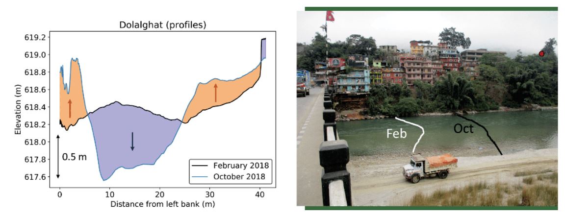
This loan was part of an ongoing effort by our team and collaborators (funded by two GCRF grants, one NERC grant and NERC PhD studentships) to understand the influence of sediment transport from mountains to basins on flooding risk for the populations living in the Indo-Gangetic Plain. In particular, the Gorkha earthquake has caused widespread landsliding, therefore contributing large amounts of sediment to the river system. This loan was part of Emma Graf’s PhD project, which is aiming to constrain the timescales of sediment transport from source areas (landslides in mountains) to sedimentary basins (Indo-Gangetic Plain). Emma’s project combines numerical modelling with field surveys to better understand (1) how and how rapidly sediment from landslides is incorporated into the river sediment load, (2) how the characteristics of this sediment evolve downstream (grain size, gravel fraction), and (3) how quickly the “slugs” of sediment are moving downstream. The observables include topographic evolution of landslide deposits, grain size characterization of landslide and gravel bar deposits, and evidence of change in channel geometry, including river bed elevation and cross-section form (as a result of deposition or erosion).
Research facilitated by this loan
The two GNSS Leica Viva GS10 were used with an Acoustic Doppler Current Profiler (ADCP) Sontek M9 mounted on a Sontek surfboard to document changes in bed form and elevation between surveys. This information is essential to complement changes in channel plan view documented from satellite imagery: the ADCP data are the only data that allow us to quantify vertical changes (as a result of aggradation or erosion) and therefore to make sediment budget estimates. The GNSS systems are essential to provide the accuracy needed: <10 cm-horizontal and <20 cm-vertical for precise location of the ADCP when it acquires depth measurements. This survey was focused on the mountainous areas downstream of the quake-affected zone which experienced heavy landsliding.
This loan is part of a long-term monitoring effort: the surveys have been supported by multiple loans of the GNSS systems. Loans 1068 and 1088 in October 2016 and August 2017 were focused in the Plains (Karnali River), and loans 1096, 1103 and 1123 have contributed to a post-monsoon repeat survey in the mountains in February 2018, October 2018 and October 2019, respectively.
Survey Methodology and Data Processing
The ADCP was mounted on a bespoke surfboard which was dragged across the river from a bridge. The ADCP was tied to a strong rope (climbing rope) hold by two people, and was mounted with the rover GNSS. The base station GPS was located on a tripod on the river bank at a site that can be clearly marked and recorded. The base station was maintained in position for at least two hours.
The maximum flow velocities rarely exceeded 3 m/s during the low flow season; the board was very easily manageable in these conditions. The majority of the rope was typically coiled up with one person on the bridge holding the neatly coiled rope. A sling could be fed through the coiled rope to clip onto the bridge with a screw-gate. A few loops of rope (typically ~5 metres) were uncoiled and held by a second team member which fed directly to the ADCP, and allowed the rope to be fed out or brought in if there were obstacles in the channel (e.g. boulders). This system eliminated any problems involving tangled ropes crossing over people, or wrapping of ropes around hands/bodies, as the ropes could very quickly be let go of or released in the event of a problem. The back up with a sling and screw-gate also meant that the ADCP did not float away. There was a team of three working on the transects, with hand-held radios to co-ordinate movements. Thick gloves were used by members operating the rope.
Because we went out during the low flow season, a large amount of the channel was exposed at some sites; we therefore surveyed both the inundated and the dry portions of the channel to characterise its bankful geometry. Before launching the ADCP and rover, the compass on the system was calibrated through a process of pitching and rolling the board. For example, see video on website below. For examples of surveys, go to Sontek site: http://www.sontek.com/productsdetail.php?RiverSurveyor-S5-M9-14
Both GPS and GLONASS were recorded at the base and processed in real-time by the Leica receivers (for use by the ADCP) and also by the online PPP service. The baseline ranged between 10 and 300 m (the maximum width of the river); survey locations were in open country with good satellite visibility and radio connection, though interference with other sources had been encountered in busy area such as cities - the problem was solved by having the operator with the laptop following the board on the bridge to ensure short connection distance. GNSS data was sampled at a frequency of 1 / second as in previous surveys. The RTK positions calculated by the Leica GS10 were fed in real-time to the ADCP as NMEA data and passed on to the River Surveyor software via the ADCP radio link. We have had very good support from the company that supplied the ADCP, and have found that this system has worked well on our fieldtrips. These ADCP surveys have been compared to previous years’ surveys conducted by us and by colleagues at GFZ Potsdam/University of Cambridge (which have used RTK); they will be used as a benchmark for future ADCP surveys, to assess for absolute changes in bed elevation/channel topography. Absolute bed elevations do require us to resolve for centimeter/tens of centimeter changes in absolute bed elevation, which is not achievable using a dGPS.
The data were processed in real time using the River Surveyor software (RSL v4.1) from Sontek which is a Windows 7/8/10 compatible package with the latest advancements for open channel hydraulics visualization. We required relative accuracy of a few cms which was achieved over the planned short baselines. For referencing to an absolute datum, we recorded static data at the base station during the survey for post-processing using an online PPP service as suggested in NERC GEF documentation.
Project Outcomes
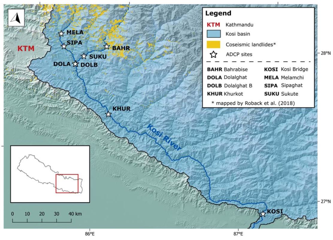
The two GNSS systems and ADCP performed very well and the quality of the information recorded was high. We were able to revisit two field sites (MELA and DOLB on Fig. 1) where satellite coverage in October 2018 was insufficient, and have now acquired accurate coordinates for the base station that will enable us to correct the October 2018 RTK positions.
When comparing our data with preliminary data collected in previous years with the GFZ instruments, we noticed that direct comparison was going to be difficult as the reference points had not been established as precisely as would be needed in previous years (likely due to the exploratory nature of previous surveys in this area). This is an ongoing issue, but thanks to the assistance of the GEF staff and in cooperation with the GFZ team, we have managed to minimise the uncertainty in the 2015 data. This will enable us to make reasonable comparisons with our data. As in the February and October 2018 field seasons, we surveyed all reference points and added extra reference information (e.g., water level with respect to reference points on bridge) with great care. This will greatly facilitate direct comparison with data from subsequent surveys.
Addendum, July 2021: the MELA site (Melamchi) has been the victim of a catastrophic outburst flood in June 2021, causing huge devastation and up to 10 meters of sediment aggradation in place. The bridge from which we surveyed the site has been destroyed, as well as a large part of the city, as can be seen on the first picture at https://www.nepalitimes.com/banner/drones-to-the-rescue-in-melamchi/
Emma is currently working on characterising the event, and the data we have collected will be very valuable to quantify the magnitude of the damage.
Outputs
As mentioned earlier, this work is part of a long-term monitoring effort. A policy brief relating to flood prediction using river discharge measurements has been published in 2017, accessible at the following address: https://reliefweb.int/report/nepal/improving-understanding-flooding-and-resilience-terai-nepal
The work supported by loans 1096 and 1103 has been presented at the European Geosciences Union in April 2019, the 6th EGU Galileo Conference in October 2019, and the European Geosciences Union in May 2020:
- Graf, E., Attal, M., Sinclair, H.D. Evacuation of earthquake-triggered landslide sediment in the Nepalese Himalaya. Geophysical Research Abstracts, Vol. 21, EGU2019-9446, 2019 (available at https://meetingorganizer.copernicus.org/EGU2019/EGU2019-9446.pdf).
- Graf, E., Sinclair, H.D., Attal, M. Source to sink: the journey of landslide sediment following the 2015 Gorkha earthquake. Galileo conference: Perturbations of earth surface dynamics caused by extreme events, October 2019, Nepal (https://www.egu-galileo.eu/gc6-perturbations/about/general_information.html).
- Graf, E., Sinclair, H.D., Attal, M. Where does all the gravel go? Tracking landslide sediment from the 2015 Gorkha earthquake along the Kosi River, Nepal. EGU2020-455, https://doi.org/10.5194/egusphere-egu2020-455.
A paper is in preparation.
Data Archiving
When all data will have been cleaned and made archivable, they will be stored at the National Geoscience Data Centre (NGDC) at the BGS supervised by Rod Bowie as records manager. We are forecasting archiving to be done by the end of 2021, and mid-2022 the latest. This may feel late for data collected in 2019 but Emma Graf has interrupted her studies for 8 months to work on side projects relevant to nuclear waste disposal, and covid-19 has caused delays to the production and analysis of data.
Files will be supplied as either ASCII or .xls for the data and .shp files for GIS data.
Figures and tables


