Scientific Report 1122
This is a Reduced Scientific Report resulting from our minor loan scheme.
Summary
Equipment from the NERC Geophysical Equipment facility, along with additional UAV and thermal equipment, was used to undertake field-based data collection at Llaca Glacier, Cordillera Blanca, Peru. The data collection consisted of two geo-referenced UAV surveys of the glacier tongue (visible and thermal) as well as ground-based thermal monitoring. The data was collected in order to investigate the surface characteristics, especially with respect to debris, and topographic evolution of the Llaca Glacier.
Research facilitated by this loan
The glaciers in the Cordillera Blanca, Peru, cover an area of more than 500,000 square kilometers. The meltwater from these glaciers provides a vital water resource to over 250,000 people living in the Ancash region. However, as these glaciers retreat, both the quantity and the quality of these water resources are being impacted significantly.
Many of the glaciers in this region are blanketed in rock material known as supraglacial debris cover, which can influence their melt rate significantly. A thin layer of debris enhances melt rates by darkening the glacier surface and causing more incoming solar radiation to be absorbed. Meanwhile, a thicker layer of debris has the opposite effect, insulating the ice surface and reducing the melt rate. Therefore, quantifying the debris thickness distributed across the glacier surface is important for modelling glacier melt rates. A key aim of our project is to use UAV-derived thermal imagery to model the thickness of the debris across the glacier tongue and investigate the influence of this debris on glacier melt rates, both currently and in the future, in the Cordillera Blanca.
Debris-covered glaciers are often covered with exposed ice cliffs and meltwater ponds, which promote localised areas of enhanced melting. In order to understand more about the melt rate and retreat rate of the glaciers in this region, it is important to understand more about the characteristics of these features and how they are evolving over time. Therefore, another key aim of our project is to use UAV-derived visible imagery to generate a highresolution DEM of the glacier surface in 2019. Using this DEM, in conjunction with DEMs collected in previous years (Wigmore et al., 2017)1, our project aims to quantify ice surface thinning on the tongue of the glacier and investigate the properties of surface features (e.g. size, shape, slope, aspect). By doing so, we hope to gain a better understanding of the melt processes occurring at Llaca Glacier (and other glaciers across the region) and how these processes are contributing to overall glacial retreat rates.
Survey Methodology and Data Processing
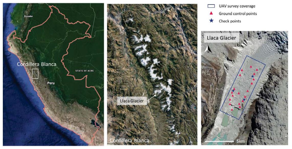
Two aerial surveys were carried out in order to collect thermal and visible imagery of the surface of Llaca Glacier (Figure 1). Prior to each of the surveys, a ground control survey was conducted, where the location of 25 ground control points were accurately measured using two Leica GS10 GNSS systems. One of the Leica systems was set up at a stationary position on bedrock in front of the glacier, while the other system was used to collect the position of each of the 25 points across the glacier surface. Following data collection, GEF sent the data collected from the base system to AUSPOS for correction. GEF kindly processed the data collected with the rover using Leica Infinity (which was inaccessible to us at the time due to COVID-19). With the processed coordinates of our ground control points, the imagery was stitched together and geo-referenced using Agisoft Metashape and Pix4D Mapping software.
Project Outcomes
The GNSS equipment performed very well in the field without any technical difficulties. GEF provided us with detailed instructions and demonstrations, which prepared us thoroughly for operating the equipment. As a result, we were able to collect two sets of 25 GPS positions, which were used to accurately georeference the images collected during both the visible and thermal drone surveys. Using the georeferenced visible imagery produced, we are in the process of quantifying the surface thinning of Llaca Glacier and investigating the properties of surface features which alter the melt rate of the glacier. Additionally, using the thermal imagery produced, we are currently working on modelling the thickness of the debris layer covering the glacier, in order to model glacier melt rates. This research is feeding into the NERC-funded CASCADA project (on which Nienow is a co-I), which is focused on investigating the impacts of glacial retreat on water resources in the Ancash region of Peru.
Outputs
This research project is still underway but is progressing well with exciting results already emerging. We expect to produce two scientific publications from this research and to present the research at a major conference, likely EGU in the coming year.
Data Archiving
Upon publication of our research, the data will be archived (either in the supplementary materials of the article or in a data repository as appropriate) in line with NERC policy.
References
-
Wigmore, O., Mark, B. (2017) Monitoring tropical debris-covered glacier dynamics from high-resolution unmanned aerial vehicle photogrammetry, Cordillera Blanca, Peru. The Cryosphere. 11, 24632480. ↩
Figures and tables

