Scientific Report 1049
This is a Reduced Scientific Report resulting from our minor loan scheme.
Summary
Since the early 2000’s the Greenland Ice Sheet (GrIS) has lost mass at an accelerating rate, half this mass loss is due to increased production of icebergs (calving) from glaciers terminating in the sea (tidewater glaciers). Our ability to predict the future stability of the GrIS depends on understanding the long-term relationship between climate and mass loss by calving of tidewater glaciers.
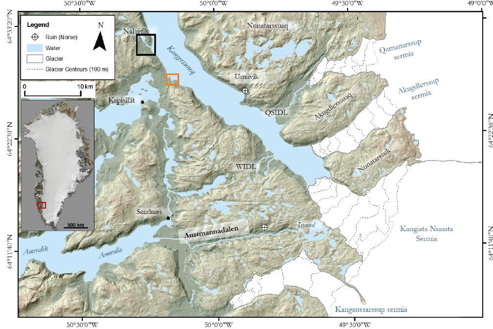
This project focuses upon Kangiata Nunata Sermia (KNS), the most dynamic tidewater glacier in SW Greenland (See Figure 1) where we exploit a unique combination of glacial geomorphology, sedimentology and archaeology (remnants of Norse settlements) to reconstruct this glacier’s advance, as well as retreat, over the last millennium. The terrestrial proxies are in the process of being independently validated by the analysis of annual growth bands of coralline algae in the adjacent fjord waters. This long-term record will be used to validate models which link calving to climate and has already shed new insights into the timings of settlement/abandonment of the Norse people.
Research facilitated by this loan
The project identified a series of palaeo-shorelines associated with KNS. These had never previously been recorded and a detailed survey would allow constraint on progressive ice thinning during retreat. This data would subsequently be used to constrain numerical modelling experiments.
We requested and were loaned a pair of Global Navigation Satellite Systems (GNSS) Receivers with Real-Time Kinematic (RTK) positioning (if available). Ideal accuracy required: <1 m. Leica 1200 GPS, base station tripod (GST05).
We selected August to conduct field work because there was minimal snow in the proglacial area, making the glacial geomorphology clearer, which enabled us to use the GPS to record the landforms. In addition, there is usually a high pressure system located over south-west Greenland, resulting in drier weather, which maximised the clear conditions for the equipment.
Survey Methodology and Data Processing
The field site : western proglacial area of KNS (See square black box in Figure 1). Approximate coordinates: 64 21’44.53”N; 49 50’49.42”W to 64 19’31.98”N 49 44’52.60”W to 64 19’27.27”N 49 52’06.33”W
Prior to field work, we conducted detailed analyses of aerial photography and satellite imagery which revealed a suite of shorelines formed when KNS was considerable further down-fjord. The mapping carried out by DP was ground-truthed and we decided to determine the elevations of the multiple shorelines (>10). This would provide important insights into progressive ice-thinning during retreat.
Upon arrival, the area around the black box (See Figure 1) was walked over by the team and we set up the base station (See Figure 1, orange box). D.Pearce called the GEF Edinburgh office to ensure the set-up was correct. We surveyed the shorelines using single-point recordings, keeping the rover in the same vertical position for c. 5minutes to ensure an accurate data point was recorded using the Leica rover. However, the base station was set up c. 10km from the shorelines and upon our return the base station battery has died within three hours of the team setting off. This was due to ice conditions in the fjord making our initial base camp location inaccessible requiring a longer survey baseline than had been originally planned. Consequently the spot height recordings were only accurate to within c.8m, rather than sub meter accuracy (this was confirmed with the GEF office upon returning the equipment). Despite this, it is envisaged that the approximate heights will be used to provide a vertical ice height constraint for numerical modelling because these shorelines have never previously been documented.
Project Outcomes
The facility provided excellent instruments for which we are very grateful. It was unfortunate that the base station battery died, despite being charged the night before, but this data was not central to the success of the project since it only formed one aspect. The cold Greenlandic weather probably impacted upon the battery life as well as the location of the base station, which was probably slightly out of range of the rover. However, these are the trials of working in remote environments and we were constrained by where we could set up the base station as well as time (we only had one day to visit this area).
Outputs
The mapping of the shorelines is present in a number of outputs:
Explorathon, Aberdeen Science Centre, 2017 - ‘The Greenland Ice Sheet’ Danni Pearce
European Geoscience Union, Vienna, 2016 - ‘Reconstructing the behaviour of a major SW Greenland tidewater glacier over the last millennium.’ Danni Pearce, Douglas Mair, Brice Rea, James Schofield, James Lea, Nicholas Kamenos, Kathryn Schoenrock, and Lukasz Stachnik.
Pearce D, Mair D, Rea B, Lea J, Schofield E, Kamenos N and Schoenrock K (Accepted subject to revisions) The glacial geomorphology of upper Godth bsfjord (Nuup Kangerlua) in south-west Greenland. Journals of Maps.
European Geoscience Union, Vienna, 2017 ‘Rapid advance, and rapid retreat at Kangiata Nunaata Sermia: potential for long term numerical model validation of Greenland outlet glacier dynamics.’ Danni Pearce, Douglas Mair, Brice Rea, James Schofield, James Lea, Nicholas Kamenos.
European Geoscience Union, Vienna, 2017 - ‘Marine algae inform past calving rates of a tide water glacier in western Greenland’. Nicholas Kamenos, James Lea, Kathryn Schoenrock Danni Pearce, Douglas Mair, Brice Rea, James Schofield.
European Geoscience Union, Vienna, 2017- ‘A millennial-scale record of tidewater glacier advance and retreat, SW Greenland’. Danni Pearce, Douglas Mair, Brice Rea, James Schofield, James Lea, Nicholas Kamenos.
British Science Festival, Aberdeen, 2017 ‘Meet the Expert - Exploring the Greenland Ice Sheet.’ Danni Pearce.
British Science Festival, Aberdeen, 2017 ‘CALVE docu-film’ Alex Ingle and CALVE team.
Liverpool Geological Society, Liverpool, 2016 Reconstructing 1000 years of tidewater glacier advance and retreat in SW Greenland: links to climate change and impacts on Norse settlement. Doug Mair.
European Geoscience Union, Vienna, 2016 - ‘Reconstructing the behaviour of a major SW Greenland tidewater glacier over the last millennium.’ Danni Pearce, Douglas Mair, Brice Rea, James Schofield, James Lea, Nicholas Kamenos, Kathryn Schoenrock, and Lukasz Stachnik.
Data Archiving
Please let Danni Pearce know if you would like the data files: d.pearce@abdn.ac.uk
Figures and tables

