Scientific Report 1048
This is a Reduced Scientific Report resulting from our minor loan scheme.
Summary
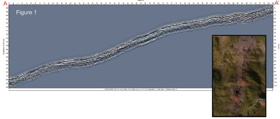
Degradation of ground-ice can trigger rapid mass movements and it is still a serious and not well-understood process in Iceland. The aim of this project is to study the Móafellshyrna landslide that occurred in summer 2012 on the Móafellshyrna Mountain in northern Iceland (Tröllaskagi peninsula) and whose main triggering factor is thought to be the degradation of ground-ice. We applied Ground Penetrating Radar (GPR) with Real Time Kinematic dGPS to ascertain the presence of ground ice and to identify the sliding surface and the inner structures of the landslide (Fig. 1). We also collected photographs in order to compute a Structure from Motion (SfM) elevation model for which we used dGPS to provide Ground Control Points (Fig. 2). We also mapped the landslide extent using dGPS. Combining these data with the airborne data (i.e., high resolution aerial photography, hyperspectral data, LiDAR data) collected by EUFAR and NERC ARSF in summer 2015, we will quantify the volumes of material (i.e., ice, water, sediments) involved during the failure and we will fully characterize the mobility of the landslide.
Research facilitated by this loan
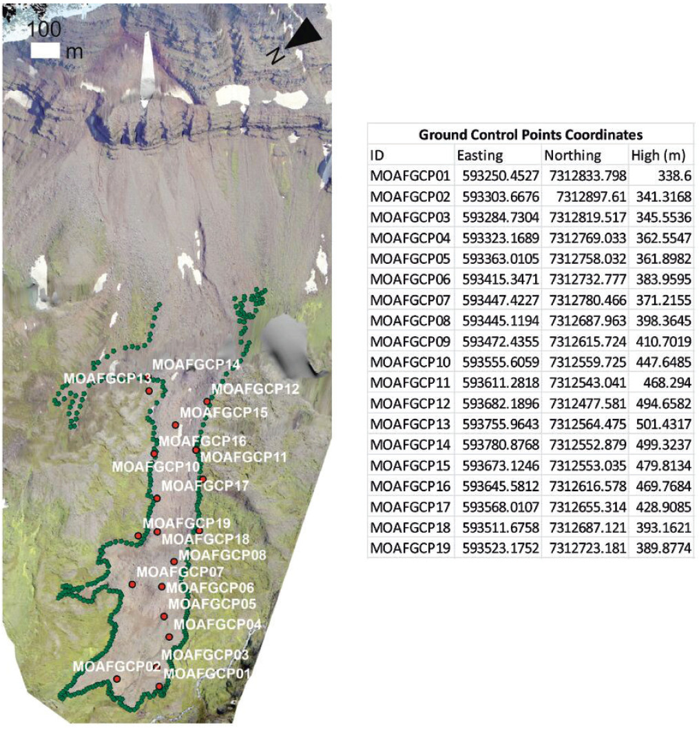
In September 2012, a debris slide occurred on the Móafellshyrna Mountain in the Tröllaskagi area (northern Iceland), mobilising ~500,000 m3 of debris. Fortunately, this landslide occurred in an uninhabited area, but future slides may not. Immediately after the event, the discovery of ice-rich blocks and sediments in the landslide deposits gave rise to the hypothesis that one of the main triggering factors for the landslide was ground-ice thaw. The melting of shallow ground-ice in mountainous areas with discontinuous permafrost is a `hidden hazard’, being a phenomenon difficult to detect and characterize and one of less understood the causes of many recent landslides in northern Iceland. In this project, we aim to study the characteristics and causes of the Móafellshyrna slide and then apply that knowledge to two other vulnerable inhabited areas in northern Iceland, with a similar potential hazard (Ísafjörður and Árnesfjall). We have used a variety of field techniques for studying these areas, but this GEF loan was used to study the Móafellshyrna slide in summer 2015. We used a Ground Penetrating Radar (pulseEKKO PRO device) provided by Loughborough University (referee: Dr John Hillier; processing software provided by GEF) with the main initial objective of detecting ground-ice in shallow loose sediments susceptible to mass movements, and the secondary objective of detecting the sliding surface and the inner structures of the landslide in different zones of its body (see Fig. 1). Knowing the thickness of the deposits mobilized by the landslide is crucial to better constrain our results from remote sensing data on the volume of the debris. We used a real-time kinematic Global Positioning System (GNSS Leica System 1200) to determine the accurate position of the instrument while surveying. Furthermore, in order to obtain a sub-metre resolution elevation model and orthophotos of the landslide to enhance the information we already have from aerial photography, hyperspectral data, LiDAR data collected in summer 2015 by EuFAR/NERC ARSF, we used the Structure from Motion photogrammetric technique (Westoby et al., 2012). In order to apply the SfM technique we needed the accurate position of at least 10 Ground Control Points (GCPs) . Thus, we used the GEF’s GNSS Leica System 1200 to collect 19 GCPs and in addition we surveyed the perimeter of the landslide (comprising 222 GPS sample points). For each of these surveys we used a rover GPS unit to collect the position of the sample points and a base station placed within the landslide body to provide differential correction (always within 5km of the rover) - both recording at 1s interval.
Project Outcomes
The field campaign was divided in two parts, the first starting on 19th July and finishing on 3rd August 2015, the second starting on 13th August and finishing on 4th September 2015. In the field we used Ground Penetrating Radar (pulseEKKO PRO device) with the main initial objective of detecting ground-ice in shallow loose sediments susceptible to mass movements. Once in the field, from the morphological characteristics and settings of the field site, we recognized that the detection of ground ice was not possible. We then decided to use the GPR for detecting the sliding surface and the inner structures of the landslide in different zones of its body (see Fig. 2). We detected the slide surface at ~2m depth. Knowing the thickness of the deposits mobilized by the landslide is crucial in order to better constrain our results from remote sensing data on volume of debris. We surveyed in total seventeen GPR profiles, using 50 MHz frequency antenna for seven of them and 100 MHz frequency antenna for the others. We used a real-time kinematic Global Positioning System during the survey to provide associated position data to the GPR. To do so, we used the GNSS Leica System 1200 with the Satelline/ADL Vantage Radio Modems for full Real-Time Kinematic corrections provided by this loan as support for the accurate geolocation of all the GPR profiles. The length of the profiles ranges from a minimum of 30 m to a maximum of 120 m. The GPR survey was completed in five days.
On this loan we also used the Leica 1200 dGPS for supporting the production of the SfM elevation model of the Moafellshyrna landslide. The SfM elevation model needs Ground Control Points in order to derive rotation, translation and scaling parameters. In one day we collected 19 GCPs (see Fig. 2), recording each point for at least 1 minute. We generated an elevation model with 37 cm/pix resolution. We also surveyed the perimeter of the landslide for obtaining the accurate position of the runout zone, collecting in total 222 samples in one day. We recorded a sample every 10-15 m, recording for at least 5 epochs (seconds).
Outputs
C. Morino, S.J. Conway, Þ. Sämundsson, M.R. Balme, J.K. Helgason, J. Hillier, C. Jordan, and T. Argles, 2016. “The effect of ground-ice on the mobility and behaviour of landslides: a case study in northern Iceland”, XI International Conference on Permafrost, 20-24 June 2016
Þ. Sæmundsson, C. Morino, J.K. Helgason, H.G. Pétursson, S.J. Conway, In Preparation. “The triggering factors of Móafellshyrna landslide: precipitation, earthquake activity or degradation of mountain permafrost?” Special Issue in Science of the Total Environment, The environmental consequences of permafrost degradation in a changing climate
Data Archiving
The data are backed up on the Open University and research group servers. Once the data have been processed and published they will be made available on request.
References
Westoby, M. J., Brasington, J., Glasser, N. F., Hambrey, M. J., & Reynolds, J. M. (2012). ‘Structure-from-Motion’ photogrammetry: A low-cost, effective tool for geoscience applications. Geomorphology, 179, 300-314.
Figures and tables