Scientific Report 1006
This is a Reduced Scientific Report resulting from our minor loan scheme.
Summary
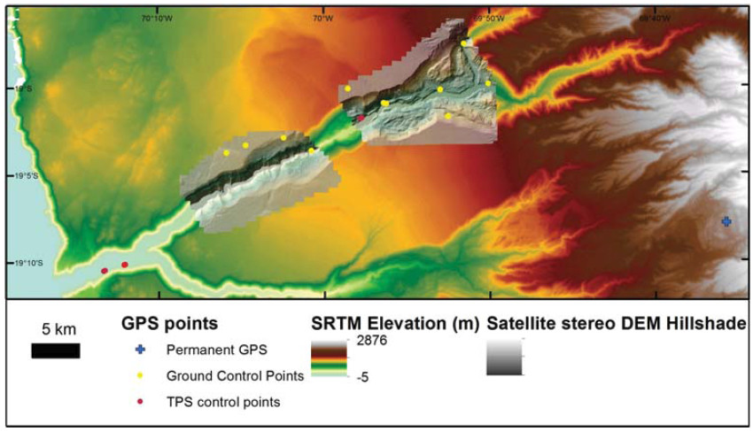
The Quebradas, south of Arica, Chile are wide, steep-sided valleys that trend east-west from the Andes mountains down to the sea. The Andes receive annual precipitation, which is transported through the Atacama Desert, one of the driest places on Earth, by the Quebradas, to the coast where fog is common due to the Humbolt current upwelling. The only source of water for the Quebradas is in the upper catchments, and therefore their walls have been affected by very few ‘wet’ processes since their initial incision. This fieldwork forms part of a funded Leverhulme project, in which we use the topographic signature of dry landscapes on the Moon and wet landscapes on Earth to investigate what role water has played in shaping Mars’ surface. The Quebradas are a dry terrestrial example in a larger dataset, comprising other desert environments and humid alpine and arctic areas. We have now characterised the topography of these Quebrada hillslopes using satellite images and structure from motion photography to generate elevation models at 2 m/pix and 0.5 m/pix respectively.
Research facilitated by this loan
The single Leica 1200 dGPS unit on this loan was used to collect a series of ground control points for these two types of elevation model. We used fixed continuously operating base-stations MNMI and UTAR to post-process the GPS data. 10 ground control points were used in the stereo-photogrammetric processing of a pair of GeoEye satellite images. We also took ground control points to act as the foresights and backsights for five total station surveys. The total station data collected were used to provide 15-35 ground control points for Structure from Motion elevation models. For these GPS points the vertical and horizontal errors or standard deviations were usually < 1mm, but always < 2mm. For two points no solution was obtained in post-processing, so single point processing was used, therefore the error on the points was on the order of 0.25-0.5m.

Project Outcomes
The 2 m/pix satellite-image-derived elevation model of the Quebradas has contributed to the main output of the Leverhulme project - a paper in which the “wetness” of gullies on Mars is assessed by comparison to gullies found on the Earth and Moon. We find that gullies on Mars are more similar to debris flow and fluvial gullies than lunar examples, showing that gullies on Mars are formed by flowing water. This paper in preparation for submission to PNAS. These results have also been presented at the Geological Society’s Fermor Meeting in May 2014 and the British Society for Geomorphology Annual Meeting in September 2014.
Outputs
Conway and Balme (in prep.) Martian gullies display the topographic signature of liquid water, PNAS
Data Archiving
The data from this project are being archived on the Open University’s dedicated research servers.
